This weather event on July 29, 2026 includes:
2 states
20 counties,
12 cities,
and 61 zip codes.
There were 338 total properties that were impacted and have possible damage.
States Impacted By Hail On July 29, 2026
North Dakota
·
South Dakota
Counties Impacted By Hail On July 29, 2026
Adams, ND
·
Billings, ND
·
Bowman, ND
·
Burke, ND
·
Burleigh, ND
·
Grant, ND
·
Hettinger, ND
·
McKenzie, ND
·
McLean, ND
·
Mercer, ND
·
Morton, ND
·
Mountrail, ND
·
Oliver, ND
·
Sheridan, ND
·
Sioux, ND
·
Slope, ND
·
Stark, ND
·
Williams, ND
·
Corson, SD
·
Perkins, SD
Cities Impacted By Hail On July 29, 2026
Amidon, ND
·
Bismarck, ND
·
New Salem, ND
·
Pick City, ND
·
Reeder, ND
·
Regent, ND
·
Riverdale, ND
·
Scranton, ND
·
Stanton, ND
·
Underwood, ND
·
Washburn, ND
·
White Earth, ND
Zip Codes Impacted By Hail On July 29, 2026
57638
·
57640
·
57641
·
57644
·
57660
·
58430
·
58463
·
58477
·
58494
·
58501
·
58503
·
58504
·
58520
·
58521
·
58523
·
58529
·
58530
·
58531
·
58533
·
58535
·
58540
·
58541
·
58545
·
58554
·
58559
·
58562
·
58563
·
58565
·
58566
·
58568
·
58570
·
58571
·
58575
·
58576
·
58577
·
58579
·
58601
·
58620
·
58622
·
58623
·
58631
·
58638
·
58639
·
58641
·
58645
·
58646
·
58647
·
58649
·
58650
·
58651
·
58653
·
58735
·
58746
·
58763
·
58773
·
58775
·
58776
·
58779
·
58784
·
58794
·
58852
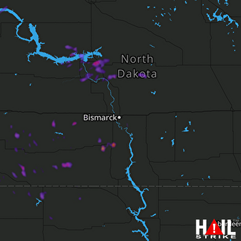 BISMARCK (KBIS) RADAR

