This weather event on July 17, 2026 includes:
2 states
30 counties,
12 cities,
and 54 zip codes.
There were 125 total properties that were impacted and have possible damage.
States Impacted By Hail On July 17, 2026
Georgia
·
South Carolina
Counties Impacted By Hail On July 17, 2026
Appling, GA
·
Atkinson, GA
·
Ben Hill, GA
·
Bleckley, GA
·
Brantley, GA
·
Bulloch, GA
·
Burke, GA
·
Candler, GA
·
Coffee, GA
·
Emanuel, GA
·
Irwin, GA
·
Jeff Davis, GA
·
Jefferson, GA
·
Jenkins, GA
·
Johnson, GA
·
Laurens, GA
·
Montgomery, GA
·
Pierce, GA
·
Richmond, GA
·
Screven, GA
·
Tattnall, GA
·
Telfair, GA
·
Toombs, GA
·
Treutlen, GA
·
Ware, GA
·
Washington, GA
·
Wheeler, GA
·
Aiken, SC
·
Barnwell, SC
·
Lexington, SC
Cities Impacted By Hail On July 17, 2026
Ailey, GA
·
Ambrose, GA
·
Augusta-Richmond County consolidated government (balance), GA
·
Broxton, GA
·
Jacksonville, GA
·
Louisville, GA
·
Mount Vernon, GA
·
Nunez, GA
·
Perry, SC
·
Swainsboro, GA
·
Tarrytown, GA
·
Wadley, GA
Zip Codes Impacted By Hail On July 17, 2026
29006
·
29070
·
29073
·
29123
·
29137
·
29146
·
29164
·
29805
·
29831
·
29853
·
30401
·
30410
·
30421
·
30426
·
30428
·
30434
·
30436
·
30439
·
30441
·
30442
·
30445
·
30448
·
30452
·
30455
·
30456
·
30457
·
30458
·
30467
·
30470
·
30474
·
30477
·
30815
·
30830
·
31002
·
31018
·
31022
·
31027
·
31049
·
31060
·
31065
·
31082
·
31512
·
31513
·
31516
·
31519
·
31533
·
31535
·
31539
·
31542
·
31544
·
31552
·
31554
·
31624
·
31798
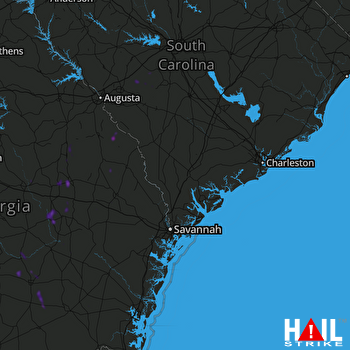 CHARLESTON (KCLX) RADAR

