This weather event on July 15, 2026 includes:
1 states
9 counties,
25 cities,
and 52 zip codes.
There were 937 total properties that were impacted and have possible damage.
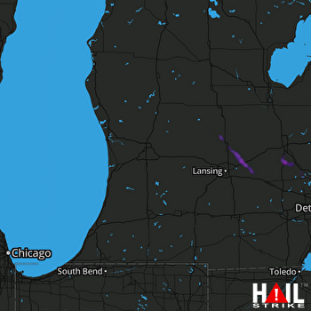 GRAND RAPIDS (KGRR) RADAR
States Impacted By Hail On July 15, 2026
Michigan
Counties Impacted By Hail On July 15, 2026
Clinton, MI
·
Genesee, MI
·
Gratiot, MI
·
Ingham, MI
·
Livingston, MI
·
Macomb, MI
·
Oakland, MI
·
Shiawassee, MI
·
Wayne, MI
Cities Impacted By Hail On July 15, 2026
Auburn Hills, MI
·
Birmingham, MI
·
Bloomfield Hills, MI
·
Center Line, MI
·
Clawson, MI
·
Detroit, MI
·
Eastpointe, MI
·
Fenton, MI
·
Fowlerville, MI
·
Holly, MI
·
Howell, MI
·
Laingsburg, MI
·
Lake Fenton, MI
·
Lake Victoria, MI
·
Linden, MI
·
Perry, MI
·
Pontiac, MI
·
Rochester Hills, MI
·
Roseville, MI
·
Royal Oak, MI
·
Sterling Heights, MI
·
St. Johns, MI
·
Troy, MI
·
Village of Clarkston, MI
·
Warren, MI
Zip Codes Impacted By Hail On July 15, 2026
48009
·
48015
·
48017
·
48021
·
48066
·
48073
·
48083
·
48084
·
48085
·
48088
·
48089
·
48091
·
48092
·
48093
·
48098
·
48205
·
48234
·
48302
·
48304
·
48309
·
48310
·
48312
·
48326
·
48327
·
48329
·
48340
·
48341
·
48342
·
48346
·
48348
·
48350
·
48386
·
48397
·
48430
·
48439
·
48442
·
48451
·
48473
·
48808
·
48811
·
48836
·
48840
·
48843
·
48848
·
48855
·
48856
·
48866
·
48871
·
48872
·
48879
·
48892
·
48895

