This weather event on July 8, 2026 includes:
1 states
19 counties,
15 cities,
and 55 zip codes.
There were 316 total properties that were impacted and have possible damage.
States Impacted By Hail On July 8, 2026
Montana
Counties Impacted By Hail On July 8, 2026
Beaverhead, MT
·
Blaine, MT
·
Broadwater, MT
·
Cascade, MT
·
Chouteau, MT
·
Deer Lodge, MT
·
Fergus, MT
·
Gallatin, MT
·
Granite, MT
·
Hill, MT
·
Jefferson, MT
·
Judith Basin, MT
·
Lewis and Clark, MT
·
Madison, MT
·
Meagher, MT
·
Park, MT
·
Phillips, MT
·
Teton, MT
·
Wheatland, MT
Cities Impacted By Hail On July 8, 2026
Anaconda-Deer Lodge County, MT
·
Black Eagle, MT
·
Choteau, MT
·
Clancy, MT
·
Gallatin River Ranch, MT
·
Geyser, MT
·
Great Falls, MT
·
Hays, MT
·
Helena Valley Northwest, MT
·
Helena Valley West Central, MT
·
Lodge Pole, MT
·
Marysville, MT
·
Montana City, MT
·
Spokane Creek, MT
·
Wheatland, MT
Zip Codes Impacted By Hail On July 8, 2026
59036
·
59047
·
59053
·
59085
·
59401
·
59404
·
59405
·
59412
·
59414
·
59416
·
59420
·
59421
·
59422
·
59424
·
59430
·
59433
·
59442
·
59446
·
59447
·
59450
·
59460
·
59469
·
59472
·
59479
·
59489
·
59501
·
59520
·
59523
·
59524
·
59525
·
59526
·
59527
·
59528
·
59530
·
59535
·
59540
·
59602
·
59631
·
59632
·
59633
·
59634
·
59635
·
59638
·
59640
·
59645
·
59647
·
59648
·
59711
·
59714
·
59715
·
59741
·
59752
·
59759
·
59761
·
59762
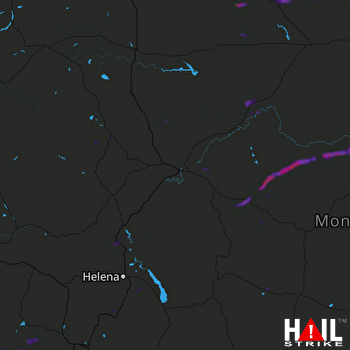 GREAT FALLS (KTFX) RADAR

