This weather event on June 27, 2026 includes:
2 states
19 counties,
12 cities,
and 66 zip codes.
There were 1966 total properties that were impacted and have possible damage.
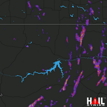 GLASGOW (KGGW) RADAR
States Impacted By Hail On June 27, 2026
Montana
·
North Dakota
Counties Impacted By Hail On June 27, 2026
Blaine, MT
·
Custer, MT
·
Daniels, MT
·
Dawson, MT
·
Garfield, MT
·
McCone, MT
·
Musselshell, MT
·
Phillips, MT
·
Prairie, MT
·
Richland, MT
·
Roosevelt, MT
·
Rosebud, MT
·
Sheridan, MT
·
Treasure, MT
·
Valley, MT
·
Wibaux, MT
·
Divide, ND
·
McKenzie, ND
·
Williams, ND
Cities Impacted By Hail On June 27, 2026
Circle, MT
·
Fortuna, ND
·
Fox Lake, MT
·
Froid, MT
·
Grenora, ND
·
Medicine Lake, MT
·
Plentywood, MT
·
Scobey, MT
·
Westby, MT
·
Wibaux, MT
·
Williston, ND
·
Wolf Point, MT
Zip Codes Impacted By Hail On June 27, 2026
59544
·
59542
·
59538
·
59537
·
59529
·
59524
·
59353
·
59349
·
59347
·
59339
·
59337
·
59330
·
59327
·
59322
·
59315
·
59312
·
59301
·
59276
·
59275
·
59274
·
59270
·
59263
·
59262
·
59261
·
59260
·
59259
·
59258
·
59256
·
59255
·
59254
·
59253
·
59252
·
59250
·
59248
·
59247
·
59243
·
59242
·
59241
·
59230
·
59226
·
59225
·
59223
·
59222
·
59221
·
59219
·
59218
·
59215
·
59214
·
59213
·
59212
·
59211
·
59201
·
59058
·
59054
·
59039
·
59038
·
59010
·
58856
·
58853
·
58845
·
58844
·
58843
·
58838
·
58833
·
58830
·
58801

