This weather event on June 26, 2026 includes:
3 states
19 counties,
22 cities,
and 55 zip codes.
There were 2583 total properties that were impacted and have possible damage.
States Impacted By Hail On June 26, 2026
Delaware
·
Maryland
·
Virginia
Counties Impacted By Hail On June 26, 2026
Sussex, DE
·
Calvert, MD
·
Charles, MD
·
Dorchester, MD
·
Prince George's, MD
·
St. Mary's, MD
·
Albemarle, VA
·
Augusta, VA
·
Clarke, VA
·
Culpeper, VA
·
Fairfax, VA
·
Fluvanna, VA
·
King George, VA
·
Louisa, VA
·
Nelson, VA
·
Orange, VA
·
Prince William, VA
·
Spotsylvania, VA
·
Stafford, VA
Cities Impacted By Hail On June 26, 2026
Brock Hall, MD
·
Broomes Island, MD
·
Chesapeake Ranch Estates, MD
·
Dahlgren, VA
·
Dahlgren Center, VA
·
Dale City, VA
·
Fairview Beach, VA
·
Falmouth, VA
·
Georgetown, DE
·
Lake Monticello, VA
·
Lake Wilderness, VA
·
Lusby, MD
·
Marlboro Meadows, MD
·
Marlboro Village, MD
·
Mason Neck, VA
·
Nellysford, VA
·
Palmyra, VA
·
Potomac Mills, VA
·
Southern Gateway, VA
·
Stafford Courthouse, VA
·
Upper Marlboro, MD
·
Wintergreen, VA
Zip Codes Impacted By Hail On June 26, 2026
22406
·
22405
·
20657
·
19947
·
24590
·
24472
·
24464
·
23117
·
23093
·
23084
·
23055
·
22976
·
22974
·
22967
·
22963
·
22960
·
22959
·
22958
·
22952
·
22938
·
22937
·
22920
·
22903
·
22902
·
22736
·
22611
·
22567
·
22556
·
22554
·
22553
·
22551
·
22508
·
22485
·
22448
·
22407
·
22193
·
22192
·
22079
·
21869
·
21835
·
21613
·
20774
·
20772
·
20685
·
20664
·
20662
·
20660
·
20659
·
20650
·
20636
·
20632
·
20624
·
20622
·
20621
·
20615
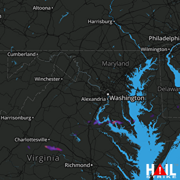 STERLING (KLWX) RADAR

