This weather event on May 29, 2026 includes:
3 states
24 counties,
12 cities,
and 61 zip codes.
There were 611 total properties that were impacted and have possible damage.
States Impacted By Hail On May 29, 2026
Kansas
·
Missouri
·
Nebraska
Counties Impacted By Hail On May 29, 2026
Allen, KS
·
Anderson, KS
·
Bourbon, KS
·
Chase, KS
·
Coffey, KS
·
Crawford, KS
·
Doniphan, KS
·
Douglas, KS
·
Franklin, KS
·
Greenwood, KS
·
Leavenworth, KS
·
Linn, KS
·
Lyon, KS
·
Marion, KS
·
Miami, KS
·
Neosho, KS
·
Osage, KS
·
Shawnee, KS
·
Wabaunsee, KS
·
Andrew, MO
·
Christian, MO
·
Webster, MO
·
Nemaha, NE
·
Richardson, NE
Cities Impacted By Hail On May 29, 2026
Blue Mound, KS
·
Bronson, KS
·
Cedar Point, KS
·
Highland, KS
·
Mapleton, KS
·
Olpe, KS
·
Osawatomie, KS
·
Overbrook, KS
·
Prescott, KS
·
Reading, KS
·
Stella, NE
·
Topeka, KS
Zip Codes Impacted By Hail On May 29, 2026
64483
·
64485
·
65652
·
65742
·
66010
·
66026
·
66035
·
66039
·
66040
·
66048
·
66056
·
66064
·
66067
·
66071
·
66072
·
66076
·
66079
·
66092
·
66401
·
66413
·
66414
·
66423
·
66451
·
66523
·
66524
·
66528
·
66533
·
66537
·
66539
·
66606
·
66617
·
66618
·
66701
·
66716
·
66733
·
66738
·
66743
·
66751
·
66754
·
66755
·
66767
·
66769
·
66779
·
66780
·
66801
·
66843
·
66850
·
66851
·
66854
·
66856
·
66860
·
66861
·
66864
·
66865
·
66868
·
68305
·
68337
·
68376
·
68414
·
68437
·
68442
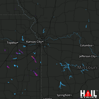 KANSAS CITY (KEAX) RADAR

