Hail Map For May 17, 2026 (KCAE)

This weather event on May 17, 2026 includes: 1 states 19 counties, 12 cities, and 38 zip codes.
There were total properties that were impacted and have possible damage.
Preview image 
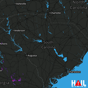
COLUMBIA (KCAE) RADAR
Weather Data Verified By
Data provided by NOAA. Data provided by NWS.

Impact Score

2

Hail Size

Average 1.3"
Maximum 1.8"

Storm Details

Start Time
02:43 PM
Properties
Spotters
1
GROUND VERIFIED

States Impacted By Hail On May 17, 2026

Georgia

Counties Impacted By Hail On May 17, 2026

Baldwin, GA · Banks, GA · Candler, GA · Clarke, GA · Emanuel, GA · Franklin, GA · Greene, GA · Hancock, GA · Johnson, GA · Laurens, GA · Madison, GA · Montgomery, GA · Oglethorpe, GA · Putnam, GA · Toombs, GA · Treutlen, GA · Washington, GA · Wheeler, GA · Wilkinson, GA

Cities Impacted By Hail On May 17, 2026

Athens-Clarke County unified government (balance), GA · Canoochee, GA · Colbert, GA · Crooked Creek, GA · Dublin, GA · Nunez, GA · Oak Park, GA · Oconee, GA · Soperton, GA · Swainsboro, GA · Winterville, GA · Wrightsville, GA

Zip Codes Impacted By Hail On May 17, 2026

30436 · 31096 · 31090 · 31089 · 31087 · 31082 · 31067 · 31061 · 31054 · 31049 · 31031 · 31027 · 31024 · 31022 · 31021 · 31002 · 30683 · 30678 · 30646 · 30642 · 30633 · 30628 · 30601 · 30530 · 30521 · 30474 · 30471 · 30470 · 30457 · 30454 · 30448 · 30445 · 30441 · 30439 · 30428 · 30425 · 30410 · 30401