This weather event on May 17, 2026 includes:
1 states
29 counties,
22 cities,
and 62 zip codes.
There were 112 total properties that were impacted and have possible damage.
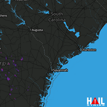 CHARLESTON (KCLX) RADAR
States Impacted By Hail On May 17, 2026
Georgia
Counties Impacted By Hail On May 17, 2026
Appling, GA
·
Atkinson, GA
·
Bacon, GA
·
Ben Hill, GA
·
Bleckley, GA
·
Brantley, GA
·
Candler, GA
·
Clinch, GA
·
Coffee, GA
·
Dodge, GA
·
Emanuel, GA
·
Hancock, GA
·
Jeff Davis, GA
·
Johnson, GA
·
Jones, GA
·
Laurens, GA
·
Montgomery, GA
·
Pierce, GA
·
Pulaski, GA
·
Tattnall, GA
·
Telfair, GA
·
Toombs, GA
·
Treutlen, GA
·
Twiggs, GA
·
Ware, GA
·
Wayne, GA
·
Wheeler, GA
·
Wilcox, GA
·
Wilkinson, GA
Cities Impacted By Hail On May 17, 2026
Ailey, GA
·
Alston, GA
·
Argyle, GA
·
Canoochee, GA
·
Douglas, GA
·
Dublin, GA
·
Eastman, GA
·
Hazlehurst, GA
·
Jacksonville, GA
·
Lumber City, GA
·
McRae-Helena, GA
·
Mount Vernon, GA
·
Nunez, GA
·
Oak Park, GA
·
Offerman, GA
·
Patterson, GA
·
Pearson, GA
·
Screven, GA
·
Soperton, GA
·
Swainsboro, GA
·
Tarrytown, GA
·
Uvalda, GA
Zip Codes Impacted By Hail On May 17, 2026
31518
·
31798
·
31750
·
31642
·
31634
·
31624
·
31623
·
31567
·
31560
·
31557
·
31556
·
31555
·
31554
·
31550
·
31549
·
31545
·
31544
·
31539
·
31535
·
31533
·
31532
·
31519
·
31516
·
31513
·
31503
·
31096
·
31087
·
31077
·
31075
·
31060
·
31055
·
31044
·
31042
·
31036
·
31033
·
31032
·
31027
·
31023
·
31021
·
31019
·
31017
·
31014
·
31011
·
31002
·
31001
·
30474
·
30473
·
30471
·
30470
·
30457
·
30454
·
30448
·
30445
·
30441
·
30439
·
30436
·
30428
·
30427
·
30412
·
30411
·
30410
·
30401

