This weather event on May 8, 2026 includes:
4 states
14 counties,
27 cities,
and 44 zip codes.
There were 14172 total properties that were impacted and have possible damage.
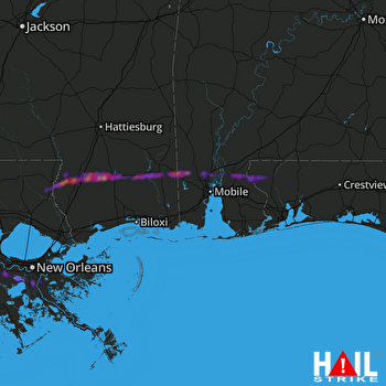 MOBILE (KMOB) RADAR
States Impacted By Hail On May 8, 2026
Alabama
·
Florida
·
Louisiana
·
Mississippi
Counties Impacted By Hail On May 8, 2026
Baldwin, AL
·
Mobile, AL
·
Escambia, FL
·
Santa Rosa, FL
·
Jefferson, LA
·
Plaquemines, LA
·
St. Charles, LA
·
St. Helena, LA
·
Tangipahoa, LA
·
Washington, LA
·
Forrest, MS
·
George, MS
·
Pearl River, MS
·
Stone, MS
Cities Impacted By Hail On May 8, 2026
Allentown, FL
·
Bay Minette, AL
·
Bayou Gauche, LA
·
Belle Chasse, LA
·
Bogalusa, LA
·
Boutte, LA
·
Chumuckla, FL
·
Creola, AL
·
Des Allemands, LA
·
Destrehan, LA
·
Estelle, LA
·
Hahnville, LA
·
Jean Lafitte, LA
·
Lucedale, MS
·
Luling, LA
·
Marrero, LA
·
Mobile, AL
·
New Sarpy, LA
·
Paradis, LA
·
Poplarville, MS
·
Prichard, AL
·
Saraland, AL
·
Satsuma, AL
·
Spanish Fort, AL
·
Timberlane, LA
·
Wiggins, MS
·
Woodmere, LA
Zip Codes Impacted By Hail On May 8, 2026
70072
·
70456
·
70450
·
70444
·
70441
·
70438
·
70427
·
70426
·
70422
·
70094
·
70080
·
70070
·
70067
·
70058
·
70057
·
70056
·
70047
·
70040
·
70039
·
70037
·
70030
·
39577
·
39573
·
39470
·
39455
·
39452
·
39426
·
36695
·
36613
·
36608
·
36587
·
36578
·
36575
·
36572
·
36571
·
36525
·
36521
·
36507
·
36505
·
32577
·
32571
·
32570
·
32568
·
32565

