This weather event on May 6, 2026 includes:
4 states
21 counties,
13 cities,
and 55 zip codes.
There were 1151 total properties that were impacted and have possible damage.
States Impacted By Hail On May 6, 2026
Alabama
·
Arkansas
·
Mississippi
·
Tennessee
Counties Impacted By Hail On May 6, 2026
Colbert, AL
·
Franklin, AL
·
Arkansas, AR
·
Crittenden, AR
·
Faulkner, AR
·
Lee, AR
·
Lonoke, AR
·
Monroe, AR
·
Phillips, AR
·
Prairie, AR
·
Pulaski, AR
·
St. Francis, AR
·
Woodruff, AR
·
Benton, MS
·
DeSoto, MS
·
Itawamba, MS
·
Lee, MS
·
Marshall, MS
·
Tishomingo, MS
·
Tunica, MS
·
Fayette, TN
Cities Impacted By Hail On May 6, 2026
Anthonyville, AR
·
Belmont, MS
·
Cabot, AR
·
Cotton Plant, AR
·
Des Arc, AR
·
Fargo, AR
·
Helena-West Helena, AR
·
Little Rock, AR
·
Littleville, AL
·
Mantachie, MS
·
Mooreville, MS
·
Palestine, AR
·
Piperton, TN
Zip Codes Impacted By Hail On May 6, 2026
35593
·
35616
·
72394
·
72392
·
72390
·
72383
·
72376
·
72374
·
72372
·
72366
·
72355
·
72348
·
72346
·
72342
·
72340
·
72335
·
72207
·
72205
·
72204
·
72202
·
72176
·
72140
·
72120
·
72086
·
72074
·
72069
·
72064
·
72042
·
72040
·
72038
·
72036
·
72024
·
72023
·
72021
·
72007
·
72003
·
38857
·
38855
·
38847
·
38843
·
38827
·
38804
·
38685
·
38676
·
38659
·
38654
·
38650
·
38633
·
38626
·
38611
·
38017
·
35674
·
35654
·
35653
·
35582
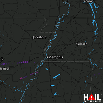 MEMPHIS (KNQA) RADAR

