This weather event on May 4, 2026 includes:
2 states
7 counties,
44 cities,
and 34 zip codes.
There were 3649 total properties that were impacted and have possible damage.
States Impacted By Hail On May 4, 2026
Illinois
·
Missouri
Counties Impacted By Hail On May 4, 2026
Clinton, IL
·
Monroe, IL
·
St. Clair, IL
·
Washington, IL
·
Franklin, MO
·
Jefferson, MO
·
St. Louis, MO
Cities Impacted By Hail On May 4, 2026
Ballwin, MO
·
Bellerive, MO
·
Belleville, IL
·
Bel-Nor, MO
·
Beverly Hills, MO
·
Chesterfield, MO
·
Columbia, IL
·
Crystal City, MO
·
Dupo, IL
·
Ellisville, MO
·
Eureka, MO
·
Festus, MO
·
Freeburg, IL
·
Glen Echo Park, MO
·
Greendale, MO
·
Hanley Hills, MO
·
Hillsdale, MO
·
Maeystown, IL
·
Manchester, MO
·
Mascoutah, IL
·
Mehlville, MO
·
Millstadt, IL
·
Normandy, MO
·
Northwoods, MO
·
Norwood Court, MO
·
Oakville, MO
·
Okawville, IL
·
Overland, MO
·
Pagedale, MO
·
Pasadena Hills, MO
·
Pasadena Park, MO
·
Pine Lawn, MO
·
Smithton, IL
·
University City, MO
·
Uplands Park, MO
·
Valmeyer, IL
·
Velda City, MO
·
Velda Village Hills, MO
·
Venedy, IL
·
Vinita Park, MO
·
Vinita Terrace, MO
·
Wellston, MO
·
Wildwood, MO
·
Winchester, MO
Zip Codes Impacted By Hail On May 4, 2026
63133
·
63132
·
63130
·
63129
·
63125
·
63121
·
63114
·
63069
·
63040
·
63038
·
63028
·
63025
·
63021
·
63019
·
63017
·
63011
·
62298
·
62295
·
62285
·
62271
·
62265
·
62260
·
62258
·
62257
·
62244
·
62243
·
62240
·
62239
·
62236
·
62226
·
62223
·
62221
·
62220
·
62214
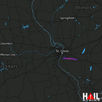 ST LOUIS (KLSX) RADAR

