This weather event on April 27, 2026 includes:
1 states
22 counties,
25 cities,
and 87 zip codes.
There were 1475 total properties that were impacted and have possible damage.
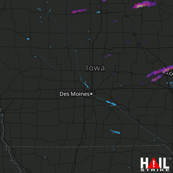 DES MOINES (KDMX) RADAR
States Impacted By Hail On April 27, 2026
Iowa
Counties Impacted By Hail On April 27, 2026
Benton, IA
·
Black Hawk, IA
·
Butler, IA
·
Cerro Gordo, IA
·
Chickasaw, IA
·
Delaware, IA
·
Des Moines, IA
·
Floyd, IA
·
Grundy, IA
·
Hancock, IA
·
Hardin, IA
·
Howard, IA
·
Iowa, IA
·
Kossuth, IA
·
Linn, IA
·
Louisa, IA
·
Marshall, IA
·
Mitchell, IA
·
Poweshiek, IA
·
Winnebago, IA
·
Winneshiek, IA
·
Worth, IA
Cities Impacted By Hail On April 27, 2026
Alta Vista, IA
·
Atkins, IA
·
Cedar Rapids, IA
·
Eldora, IA
·
Elma, IA
·
Fairfax, IA
·
Fertile, IA
·
Hartwick, IA
·
Hayfield, IA
·
Hiawatha, IA
·
Kensett, IA
·
Luzerne, IA
·
Marengo, IA
·
Marion, IA
·
Marshalltown, IA
·
Newhall, IA
·
Norway, IA
·
Palo, IA
·
Ridgeway, IA
·
Robins, IA
·
Shellsburg, IA
·
Van Horne, IA
·
Waterloo, IA
·
Watkins, IA
·
Wellsburg, IA
Zip Codes Impacted By Hail On April 27, 2026
50122
·
50158
·
50162
·
50206
·
50247
·
50423
·
50428
·
50433
·
50434
·
50436
·
50438
·
50444
·
50446
·
50448
·
50459
·
50460
·
50466
·
50468
·
50469
·
50472
·
50480
·
50482
·
50483
·
50484
·
50511
·
50522
·
50603
·
50616
·
50624
·
50626
·
50627
·
50628
·
50638
·
50642
·
50653
·
50659
·
50660
·
50665
·
50670
·
50680
·
50703
·
52101
·
52132
·
52136
·
52154
·
52155
·
52163
·
52165
·
52171
·
52202
·
52203
·
52205
·
52206
·
52208
·
52209
·
52211
·
52214
·
52218
·
52228
·
52232
·
52233
·
52249
·
52251
·
52257
·
52301
·
52302
·
52313
·
52315
·
52318
·
52324
·
52328
·
52330
·
52332
·
52336
·
52341
·
52346
·
52347
·
52349
·
52354
·
52401
·
52402
·
52403
·
52404
·
52405
·
52411
·
52637
·
52653

