This weather event on April 26, 2026 includes:
3 states
22 counties,
27 cities,
and 72 zip codes.
There were 3249 total properties that were impacted and have possible damage.
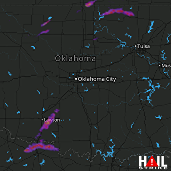 OKLAHOMA CITY (KTLX) RADAR
States Impacted By Hail On April 26, 2026
Kansas
·
Oklahoma
·
Texas
Counties Impacted By Hail On April 26, 2026
Chautauqua, KS
·
Cowley, KS
·
Elk, KS
·
Sumner, KS
·
Alfalfa, OK
·
Comanche, OK
·
Cotton, OK
·
Grady, OK
·
Grant, OK
·
Harper, OK
·
Jefferson, OK
·
Kay, OK
·
Major, OK
·
Noble, OK
·
Osage, OK
·
Pawnee, OK
·
Stephens, OK
·
Tillman, OK
·
Washington, OK
·
Woodward, OK
·
Clay, TX
·
Wichita, TX
Cities Impacted By Hail On April 26, 2026
Arkansas City, KS
·
Bartlesville, OK
·
Braman, OK
·
Burkburnett, TX
·
Byers, TX
·
Cashion Community, TX
·
Central High, OK
·
Cleo Springs, OK
·
Devol, OK
·
Empire City, OK
·
Foraker, OK
·
Geronimo, OK
·
Goltry, OK
·
Grainola, OK
·
Iowa Park, TX
·
Kaw City, OK
·
Lawton, OK
·
Morrison, OK
·
Petrolia, TX
·
Randlett, OK
·
Rush Springs, OK
·
Sedan, KS
·
Sterling, OK
·
Walters, OK
·
Webb City, OK
·
Wichita Falls, TX
·
Winfield, KS
Zip Codes Impacted By Hail On April 26, 2026
67140
·
73540
·
76377
·
76367
·
76365
·
76360
·
76357
·
76354
·
76306
·
76305
·
74652
·
74647
·
74646
·
74641
·
74636
·
74632
·
74604
·
74058
·
74056
·
74022
·
74006
·
74003
·
73860
·
73852
·
73842
·
73801
·
73768
·
73766
·
73761
·
73760
·
73759
·
73749
·
73741
·
73739
·
73737
·
73729
·
73728
·
73726
·
73716
·
73573
·
73572
·
73567
·
73565
·
73562
·
73546
·
73543
·
73541
·
73538
·
73533
·
73531
·
73528
·
73507
·
73501
·
73082
·
73077
·
73067
·
73061
·
73055
·
73017
·
67361
·
67353
·
67352
·
67346
·
67344
·
67156
·
67051
·
67038
·
67024
·
67023
·
67019
·
67008
·
67005

