This weather event on April 14, 2026 includes:
4 states
38 counties,
78 cities,
and 169 zip codes.
There were 8191 total properties that were impacted and have possible damage.
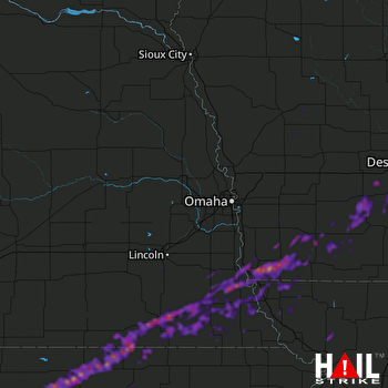 OMAHA (KOAX) RADAR
States Impacted By Hail On April 14, 2026
Iowa
·
Kansas
·
Missouri
·
Nebraska
Counties Impacted By Hail On April 14, 2026
Adair, IA
·
Adams, IA
·
Audubon, IA
·
Carroll, IA
·
Cass, IA
·
Clarke, IA
·
Crawford, IA
·
Fremont, IA
·
Madison, IA
·
Mills, IA
·
Montgomery, IA
·
Page, IA
·
Ringgold, IA
·
Shelby, IA
·
Taylor, IA
·
Union, IA
·
Warren, IA
·
Clay, KS
·
Cloud, KS
·
Jewell, KS
·
Marshall, KS
·
Republic, KS
·
Washington, KS
·
Andrew, MO
·
Atchison, MO
·
Holt, MO
·
Nodaway, MO
·
Cass, NE
·
Gage, NE
·
Jefferson, NE
·
Johnson, NE
·
Lancaster, NE
·
Nemaha, NE
·
Otoe, NE
·
Pawnee, NE
·
Platte, NE
·
Richardson, NE
·
Thayer, NE
Cities Impacted By Hail On April 14, 2026
Auburn, NE
·
Aurora, KS
·
Beatrice, NE
·
Belleville, KS
·
Bevington, IA
·
Blanchard, IA
·
Blanchard, MO
·
Blue Springs, NE
·
Bolckow, MO
·
Brock, NE
·
Brownville, NE
·
Burchard, NE
·
Burlington Junction, MO
·
Carbon, IA
·
Clifton, KS
·
Coburg, IA
·
Crab Orchard, NE
·
Cuba, KS
·
Dawson, NE
·
Des Moines, IA
·
Endicott, NE
·
Essex, IA
·
Farragut, IA
·
Filley, NE
·
Greenfield, IA
·
Haddam, KS
·
Hamburg, IA
·
Harbine, NE
·
Hepburn, IA
·
Hollenberg, KS
·
Holmesville, NE
·
Imogene, IA
·
Johnson, NE
·
Julian, NE
·
Lenox, IA
·
Lewiston, NE
·
Linn, KS
·
Lorimor, IA
·
Lorton, NE
·
Macksburg, IA
·
Mahaska, KS
·
Martensdale, IA
·
Munden, KS
·
Narka, KS
·
Nebraska City, NE
·
Odell, NE
·
Orient, IA
·
Osceola, IA
·
Patterson, IA
·
Pawnee City, NE
·
Phelps City, MO
·
Plattsmouth, NE
·
Prescott, IA
·
Quitman, MO
·
Randall, KS
·
Reynolds, NE
·
Riverton, IA
·
Rock Port, MO
·
Scandia, KS
·
Sharpsburg, IA
·
Shenandoah, IA
·
Spring Hill, IA
·
Stanton, IA
·
St. Charles, IA
·
Steinauer, NE
·
Stella, NE
·
Syracuse, NE
·
Table Rock, NE
·
Talmage, NE
·
Tarkio, MO
·
Tecumseh, NE
·
Villisca, IA
·
Vining, KS
·
Watson, MO
·
Westboro, MO
·
Winterset, IA
·
Wymore, NE
·
Yorktown, IA
Zip Codes Impacted By Hail On April 14, 2026
50857
·
51454
·
51561
·
66412
·
66940
·
66959
·
68420
·
68430
·
68457
·
68601
·
68523
·
68512
·
68466
·
68458
·
68454
·
68450
·
68448
·
68447
·
68446
·
68443
·
68442
·
68441
·
68440
·
68424
·
68422
·
68421
·
68418
·
68415
·
68414
·
68410
·
68409
·
68404
·
68382
·
68381
·
68380
·
68379
·
68378
·
68377
·
68376
·
68375
·
68370
·
68357
·
68355
·
68352
·
68350
·
68348
·
68346
·
68345
·
68344
·
68342
·
68337
·
68332
·
68329
·
68323
·
68321
·
68320
·
68318
·
68310
·
68305
·
68301
·
68048
·
67417
·
66968
·
66966
·
66963
·
66960
·
66958
·
66955
·
66953
·
66949
·
66948
·
66946
·
66945
·
66944
·
66942
·
66939
·
66938
·
66937
·
66935
·
66930
·
66901
·
66508
·
64498
·
64496
·
64491
·
64487
·
64483
·
64482
·
64476
·
64470
·
64468
·
64461
·
64449
·
64446
·
64445
·
64431
·
64428
·
64427
·
64423
·
51656
·
51654
·
51652
·
51650
·
51649
·
51648
·
51646
·
51645
·
51640
·
51639
·
51638
·
51636
·
51632
·
51631
·
51630
·
51601
·
51573
·
51566
·
51562
·
51551
·
51541
·
51540
·
51537
·
51533
·
51527
·
51467
·
51465
·
51455
·
51446
·
50864
·
50863
·
50862
·
50861
·
50859
·
50858
·
50853
·
50851
·
50849
·
50848
·
50846
·
50841
·
50839
·
50837
·
50833
·
50830
·
50801
·
50320
·
50275
·
50273
·
50261
·
50257
·
50254
·
50250
·
50240
·
50229
·
50222
·
50218
·
50213
·
50211
·
50210
·
50174
·
50160
·
50155
·
50149
·
50125
·
50074
·
50070
·
50061
·
50047
·
50033

