This weather event on April 11, 2026 includes:
4 states
21 counties,
29 cities,
and 66 zip codes.
There were 44 total properties that were impacted and have possible damage.
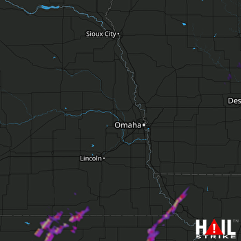 OMAHA (KOAX) RADAR
States Impacted By Hail On April 11, 2026
Iowa
·
Kansas
·
Missouri
·
Nebraska
Counties Impacted By Hail On April 11, 2026
Boone, IA
·
Calhoun, IA
·
Greene, IA
·
Guthrie, IA
·
Webster, IA
·
Brown, KS
·
Cloud, KS
·
Jackson, KS
·
Jewell, KS
·
Nemaha, KS
·
Pottawatomie, KS
·
Republic, KS
·
Washington, KS
·
Atchison, MO
·
Holt, MO
·
Nodaway, MO
·
Gage, NE
·
Jefferson, NE
·
Richardson, NE
·
Saline, NE
·
Thayer, NE
Cities Impacted By Hail On April 11, 2026
Belleville, KS
·
Big Lake, MO
·
Chester, NE
·
Courtland, KS
·
Craig, MO
·
Cuba, KS
·
Deshler, NE
·
Diller, NE
·
Endicott, NE
·
Fairview, KS
·
Goff, KS
·
Grand Junction, IA
·
Hamlin, KS
·
Havensville, KS
·
Hubbell, NE
·
Jamestown, KS
·
Morrill, KS
·
Munden, KS
·
Onaga, KS
·
Preston, NE
·
Republic, KS
·
Reserve, KS
·
Reynolds, NE
·
Rulo, NE
·
Sabetha, KS
·
Scandia, KS
·
Soldier, KS
·
Western, NE
·
Wetmore, KS
Zip Codes Impacted By Hail On April 11, 2026
64487
·
68327
·
68370
·
68464
·
68440
·
68433
·
68431
·
68377
·
68375
·
68362
·
68355
·
68352
·
68350
·
68342
·
68340
·
68338
·
68325
·
68301
·
66968
·
66966
·
66964
·
66963
·
66960
·
66959
·
66958
·
66955
·
66948
·
66946
·
66944
·
66942
·
66940
·
66939
·
66935
·
66930
·
66901
·
66550
·
66547
·
66540
·
66534
·
66527
·
66521
·
66516
·
66515
·
66436
·
66434
·
66432
·
66428
·
66425
·
66422
·
66417
·
66416
·
66407
·
64470
·
64446
·
64437
·
64428
·
50586
·
50579
·
50566
·
50217
·
50212
·
50129
·
50128
·
50107
·
50064
·
50026

