This weather event on April 1, 2026 includes:
3 states
15 counties,
16 cities,
and 53 zip codes.
There were total properties that were impacted and have possible damage.
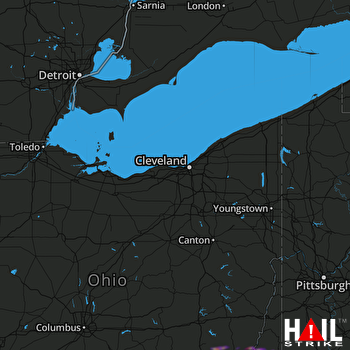 CLEVELAND (KCLE) RADAR
States Impacted By Hail On April 1, 2026
Ohio
·
Pennsylvania
·
West Virginia
Counties Impacted By Hail On April 1, 2026
Athens, OH
·
Fairfield, OH
·
Hocking, OH
·
Monroe, OH
·
Morgan, OH
·
Noble, OH
·
Perry, OH
·
Washington, OH
·
Greene, PA
·
Marion, WV
·
Marshall, WV
·
Monongalia, WV
·
Pleasants, WV
·
Wetzel, WV
·
Wood, WV
Cities Impacted By Hail On April 1, 2026
Belmont, WV
·
Boaz, WV
·
Chesterhill, OH
·
Clarington, OH
·
Devola, OH
·
Lewisville, OH
·
Logan, OH
·
Marietta, OH
·
Newport, OH
·
New Straitsville, OH
·
Reno, OH
·
Stewart, OH
·
St. Marys, WV
·
Summerfield, OH
·
Williamstown, WV
·
Woodsfield, OH
Zip Codes Impacted By Hail On April 1, 2026
43730
·
43788
·
43793
·
45715
·
45723
·
45724
·
45729
·
45732
·
45735
·
45742
·
45744
·
45750
·
45761
·
45764
·
45768
·
45778
·
45784
·
45786
·
45787
·
45711
·
43915
·
43914
·
43787
·
43779
·
43766
·
43758
·
43756
·
43754
·
43747
·
43728
·
43724
·
43716
·
43149
·
43144
·
43138
·
43135
·
43130
·
43102
·
26590
·
26585
·
26581
·
26575
·
26562
·
26187
·
26170
·
26155
·
26146
·
26134
·
26055
·
26039
·
26033
·
15352
·
15310

