This weather event on March 31, 2026 includes:
3 states
13 counties,
37 cities,
and 50 zip codes.
There were 743 total properties that were impacted and have possible damage.
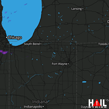 FORT WAYNE (KIWX) RADAR
States Impacted By Hail On March 31, 2026
Illinois
·
Indiana
·
Wisconsin
Counties Impacted By Hail On March 31, 2026
Cook, IL
·
Grundy, IL
·
Kankakee, IL
·
Kendall, IL
·
Lake, IL
·
Will, IL
·
Jasper, IN
·
Lake, IN
·
LaPorte, IN
·
Marshall, IN
·
Porter, IN
·
Starke, IN
·
Kenosha, WI
Cities Impacted By Hail On March 31, 2026
Bristol, WI
·
Burns Harbor, IN
·
Cedar Lake, IN
·
Channahon, IL
·
Chesterton, IN
·
Chicago Heights, IL
·
Crete, IL
·
Crown Point, IN
·
Culver, IN
·
Dyer, IN
·
Elwood, IL
·
Frankfort, IL
·
Frankfort Square, IL
·
Hobart, IN
·
Ingalls Park, IL
·
Kenosha, WI
·
Manhattan, IL
·
Matteson, IL
·
Minooka, IL
·
Mokena, IL
·
Monee, IL
·
New Lenox, IL
·
Park Forest, IL
·
Portage, IN
·
Porter, IN
·
Preston Heights, IL
·
Richton Park, IL
·
Rockdale, IL
·
Sauk Village, IL
·
Schererville, IN
·
Shorewood, IL
·
South Chicago Heights, IL
·
Steger, IL
·
St. John, IN
·
Tinley Park, IL
·
University Park, IL
·
Willowbrook, IL
Zip Codes Impacted By Hail On March 31, 2026
46303
·
46304
·
46307
·
46311
·
46340
·
46342
·
46347
·
46348
·
46360
·
46366
·
46368
·
46373
·
46374
·
46375
·
46385
·
46391
·
46392
·
46511
·
46534
·
53104
·
53142
·
60002
·
60401
·
60404
·
60410
·
60411
·
60417
·
60421
·
60423
·
60431
·
60433
·
60435
·
60436
·
60442
·
60443
·
60444
·
60447
·
60448
·
60449
·
60450
·
60451
·
60466
·
60468
·
60471
·
60475
·
60481
·
60484
·
60487
·
60586
·
60950

