This weather event on February 21, 2026 includes:
3 states
24 counties,
15 cities,
and 51 zip codes.
There were 1482 total properties that were impacted and have possible damage.
States Impacted By Hail On February 21, 2026
Alabama
·
Florida
·
Georgia
Counties Impacted By Hail On February 21, 2026
Barbour, AL
·
Coffee, AL
·
Conecuh, AL
·
Covington, AL
·
Crenshaw, AL
·
Dale, AL
·
Escambia, AL
·
Geneva, AL
·
Henry, AL
·
Houston, AL
·
Monroe, AL
·
Pike, AL
·
Escambia, FL
·
Santa Rosa, FL
·
Baker, GA
·
Calhoun, GA
·
Clay, GA
·
Crisp, GA
·
Dooly, GA
·
Dougherty, GA
·
Early, GA
·
Lee, GA
·
Sumter, GA
·
Terrell, GA
Cities Impacted By Hail On February 21, 2026
Albany, GA
·
Arabi, GA
·
Ariton, AL
·
Brantley, AL
·
Brewton, AL
·
Bronwood, GA
·
Castleberry, AL
·
Cordele, GA
·
Dothan, AL
·
Elba, AL
·
Glenwood, AL
·
Grimes, AL
·
Ozark, AL
·
River Falls, AL
·
Samson, AL
Zip Codes Impacted By Hail On February 21, 2026
31015
·
31707
·
31712
·
31719
·
31721
·
31735
·
31763
·
31780
·
31787
·
32535
·
36401
·
36420
·
36421
·
36426
·
36432
·
36442
·
36453
·
36474
·
36477
·
36502
·
39813
·
39823
·
39826
·
39842
·
39851
·
39854
·
39862
·
31092
·
32565
·
32568
·
36009
·
36010
·
36028
·
36034
·
36035
·
36049
·
36079
·
36303
·
36310
·
36311
·
36317
·
36318
·
36323
·
36330
·
36345
·
36346
·
36350
·
36351
·
36353
·
36360
·
36374
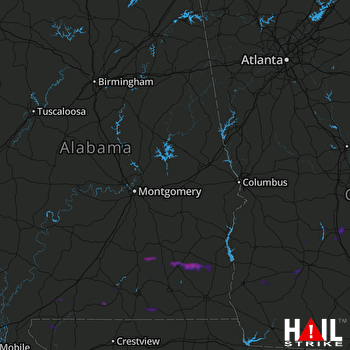 MONTGOMERY (KMXX) RADAR

