This weather event on February 19, 2026 includes:
2 states
17 counties,
22 cities,
and 59 zip codes.
There were 117 total properties that were impacted and have possible damage.
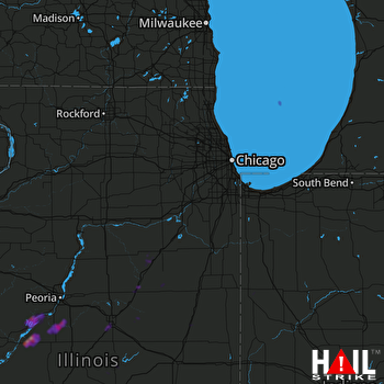 CHICAGO (KLOT) RADAR
States Impacted By Hail On February 19, 2026
Illinois
·
Indiana
Counties Impacted By Hail On February 19, 2026
Champaign, IL
·
De Witt, IL
·
Ford, IL
·
Fulton, IL
·
Grundy, IL
·
Iroquois, IL
·
LaSalle, IL
·
Livingston, IL
·
Logan, IL
·
Macon, IL
·
Marshall, IL
·
Mason, IL
·
McLean, IL
·
Peoria, IL
·
Tazewell, IL
·
Benton, IN
·
Newton, IN
Cities Impacted By Hail On February 19, 2026
Banner, IL
·
Bloomington, IL
·
Chenoa, IL
·
Clinton, IL
·
Cooksville, IL
·
Dunfermline, IL
·
Forest City, IL
·
Glasford, IL
·
Goofy Ridge, IL
·
Green Valley, IL
·
Havana, IL
·
Kingston Mines, IL
·
Manito, IL
·
Mapleton, IL
·
Normal, IL
·
Paxton, IL
·
Pekin, IL
·
South Pekin, IL
·
St. David, IL
·
Topeka, IL
·
Twin Grove, IL
·
Wenona, IL
Zip Codes Impacted By Hail On February 19, 2026
47942
·
47948
·
47951
·
60420
·
60437
·
60460
·
60470
·
60953
·
60957
·
61313
·
61319
·
61358
·
61377
·
61520
·
61705
·
61722
·
61726
·
61727
·
61728
·
61730
·
61734
·
61735
·
61739
·
61740
·
61741
·
61744
·
61749
·
61754
·
61756
·
61761
·
61764
·
61769
·
61772
·
62644
·
62633
·
62548
·
61840
·
61777
·
61776
·
61774
·
61737
·
61704
·
61701
·
61607
·
61568
·
61567
·
61564
·
61563
·
61554
·
61547
·
61546
·
61543
·
61542
·
61539
·
61534
·
61533
·
61532
·
61524
·
60936

