This weather event on February 19, 2026 includes:
4 states
24 counties,
12 cities,
and 68 zip codes.
There were 248 total properties that were impacted and have possible damage.
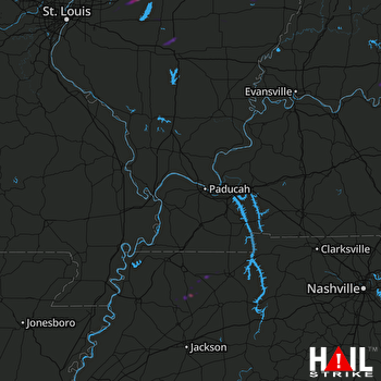 PADUCAH (KPAH) RADAR
States Impacted By Hail On February 19, 2026
Illinois
·
Indiana
·
Kentucky
·
Tennessee
Counties Impacted By Hail On February 19, 2026
Bond, IL
·
Clay, IL
·
Clinton, IL
·
Crawford, IL
·
Effingham, IL
·
Fayette, IL
·
Hardin, IL
·
Jasper, IL
·
Jefferson, IL
·
Lawrence, IL
·
Madison, IL
·
Marion, IL
·
Pope, IL
·
Richland, IL
·
Wayne, IL
·
Perry, IN
·
Breckinridge, KY
·
Christian, KY
·
Livingston, KY
·
Meade, KY
·
Gibson, TN
·
Henry, TN
·
Stewart, TN
·
Weakley, TN
Cities Impacted By Hail On February 19, 2026
Bradford, TN
·
Dix, IL
·
Dresden, TN
·
Dyer, TN
·
Greenfield, TN
·
Highland, IL
·
Kell, IL
·
Mason, IL
·
Oak Grove, KY
·
Oblong, IL
·
Pierron, IL
·
Trenton, TN
Zip Codes Impacted By Hail On February 19, 2026
37023
·
38225
·
38229
·
38230
·
38242
·
38251
·
38316
·
38330
·
38369
·
38382
·
40157
·
40170
·
42081
·
42262
·
47520
·
47525
·
47551
·
47586
·
62231
·
62246
·
62249
·
62253
·
62262
·
62275
·
62284
·
62411
·
62418
·
62421
·
62424
·
62425
·
62426
·
62432
·
62436
·
62443
·
62445
·
62448
·
62450
·
62454
·
62878
·
62880
·
62882
·
62889
·
62893
·
62898
·
62899
·
62938
·
37058
·
38201
·
38224
·
62427
·
62449
·
62458
·
62466
·
62471
·
62473
·
62475
·
62479
·
62480
·
62801
·
62823
·
62824
·
62830
·
62838
·
62839
·
62850
·
62853
·
62858
·
62864

