This weather event on February 19, 2026 includes:
4 states
20 counties,
20 cities,
and 75 zip codes.
There were 34953 total properties that were impacted and have possible damage.
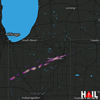 FORT WAYNE (KIWX) RADAR
States Impacted By Hail On February 19, 2026
Illinois
·
Indiana
·
Michigan
·
Ohio
Counties Impacted By Hail On February 19, 2026
Champaign, IL
·
Vermilion, IL
·
Allen, IN
·
Benton, IN
·
Carroll, IN
·
Cass, IN
·
DeKalb, IN
·
Fulton, IN
·
Huntington, IN
·
Kosciusko, IN
·
Miami, IN
·
St. Joseph, IN
·
Tippecanoe, IN
·
Wabash, IN
·
Warren, IN
·
White, IN
·
Whitley, IN
·
Cass, MI
·
Defiance, OH
·
Paulding, OH
Cities Impacted By Hail On February 19, 2026
Brookston, IN
·
Buffalo, IN
·
Burnettsville, IN
·
Chalmers, IN
·
Denver, IN
·
Fort Wayne, IN
·
Grabill, IN
·
Granger, IN
·
Harlan, IN
·
Huntertown, IN
·
Idaville, IN
·
Laketon, IN
·
Leo-Cedarville, IN
·
Logansport, IN
·
Mexico, IN
·
North Manchester, IN
·
Roann, IN
·
Rochester, IN
·
South Whitley, IN
·
Yeoman, IN
Zip Codes Impacted By Hail On February 19, 2026
43556
·
46530
·
46723
·
46725
·
46741
·
46743
·
46750
·
46835
·
46845
·
46910
·
46943
·
46946
·
46947
·
46950
·
46951
·
46958
·
46962
·
46970
·
46974
·
46975
·
46978
·
46982
·
46985
·
46988
·
46992
·
47906
·
47920
·
47944
·
47950
·
47959
·
47960
·
47970
·
47971
·
47975
·
47993
·
47995
·
47997
·
49112
·
49120
·
60942
·
60949
·
60960
·
60963
·
61847
·
43512
·
43526
·
43536
·
45813
·
45821
·
45873
·
45879
·
46510
·
46765
·
46787
·
46788
·
46797
·
46805
·
46808
·
46814
·
46818
·
46825
·
46917
·
46923
·
46926
·
46939
·
46990
·
47917
·
47918
·
47921
·
47923
·
47925
·
47926
·
47929
·
47980
·
61866

