This weather event on February 19, 2026 includes:
3 states
19 counties,
20 cities,
and 61 zip codes.
There were 11313 total properties that were impacted and have possible damage.
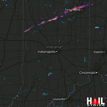 INDIANAPOLIS (KIND) RADAR
States Impacted By Hail On February 19, 2026
Illinois
·
Indiana
·
Ohio
Counties Impacted By Hail On February 19, 2026
Champaign, IL
·
Ford, IL
·
Iroquois, IL
·
Vermilion, IL
·
Allen, IN
·
Benton, IN
·
Carroll, IN
·
Cass, IN
·
DeKalb, IN
·
Fulton, IN
·
Huntington, IN
·
Kosciusko, IN
·
Miami, IN
·
Wabash, IN
·
Warren, IN
·
White, IN
·
Whitley, IN
·
Defiance, OH
·
Paulding, OH
Cities Impacted By Hail On February 19, 2026
Burnettsville, IN
·
Chalmers, IN
·
Columbia City, IN
·
Denver, IN
·
Fort Wayne, IN
·
Grabill, IN
·
Harlan, IN
·
Hicksville, OH
·
Huntertown, IN
·
Idaville, IN
·
Laketon, IN
·
Leo-Cedarville, IN
·
Logansport, IN
·
Mexico, IN
·
North Manchester, IN
·
Oxford, IN
·
Roann, IN
·
Rochester, IN
·
South Whitley, IN
·
Yeoman, IN
Zip Codes Impacted By Hail On February 19, 2026
46748
·
46750
·
46765
·
46787
·
46788
·
46797
·
46805
·
46808
·
46814
·
46818
·
46825
·
46835
·
46845
·
46910
·
46923
·
46926
·
46946
·
46947
·
46951
·
46958
·
46962
·
46970
·
46974
·
46975
·
46978
·
46982
·
46988
·
46992
·
47917
·
47921
·
47923
·
47926
·
47929
·
47944
·
47950
·
60942
·
60949
·
60957
·
60960
·
60963
·
61847
·
43526
·
43536
·
43556
·
45813
·
45821
·
46510
·
46706
·
46723
·
46725
·
46741
·
46743
·
47959
·
47960
·
47970
·
47971
·
47975
·
47980
·
47993
·
47997
·
60924

