This weather event on December 28, 2025 includes:
2 states
14 counties,
31 cities,
and 72 zip codes.
There were total properties that were impacted and have possible damage.
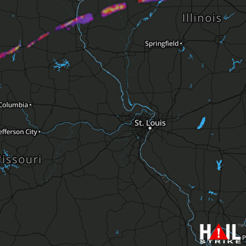 ST LOUIS (KLSX) RADAR
States Impacted By Hail On December 28, 2025
Illinois
·
Missouri
Counties Impacted By Hail On December 28, 2025
Adams, IL
·
Fulton, IL
·
Hancock, IL
·
Mason, IL
·
McDonough, IL
·
Peoria, IL
·
Schuyler, IL
·
Tazewell, IL
·
Chariton, MO
·
Knox, MO
·
Lewis, MO
·
Linn, MO
·
Macon, MO
·
Shelby, MO
Cities Impacted By Hail On December 28, 2025
Augusta, IL
·
Banner, IL
·
Bevier, MO
·
Bowen, IL
·
Bryant, IL
·
Callao, MO
·
Canton, MO
·
Cuba, IL
·
Dunfermline, IL
·
Ewing, MO
·
Goofy Ridge, IL
·
Industry, IL
·
Leonard, MO
·
Lewistown, IL
·
Lewistown, MO
·
Lima, IL
·
Liverpool, IL
·
Loraine, IL
·
Mackinaw, IL
·
Macon, MO
·
Manito, IL
·
Mendon, IL
·
Morton, IL
·
Pekin, IL
·
Plevna, MO
·
Plymouth, IL
·
Smithfield, IL
·
South Pekin, IL
·
St. David, IL
·
Tremont, IL
·
Ursa, IL
Zip Codes Impacted By Hail On December 28, 2025
61431
·
61440
·
61441
·
61452
·
61455
·
61477
·
61482
·
61519
·
61520
·
61524
·
61534
·
61535
·
61542
·
61543
·
61546
·
61547
·
61550
·
61554
·
61563
·
61564
·
61567
·
61568
·
61607
·
61747
·
61755
·
61759
·
62311
·
62316
·
62321
·
62326
·
62339
·
62348
·
62349
·
62351
·
62367
·
62373
·
62376
·
62379
·
63438
·
63440
·
63446
·
63447
·
63448
·
63451
·
63452
·
63458
·
63460
·
63464
·
63469
·
63530
·
63532
·
63534
·
63538
·
63539
·
63552
·
63558
·
64631
·
64658
·
64660
·
64676
·
65261
·
65281
·
63457
·
63437
·
63435
·
63434
·
63431
·
62644
·
62380
·
62346
·
61427
·
61415

