This weather event on November 19, 2025 includes:
2 states
17 counties,
17 cities,
and 70 zip codes.
There were total properties that were impacted and have possible damage.
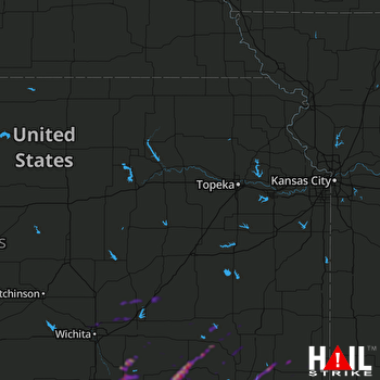 TOPEKA (KTWX) RADAR
States Impacted By Hail On November 19, 2025
Kansas
·
Oklahoma
Counties Impacted By Hail On November 19, 2025
Butler, KS
·
Chautauqua, KS
·
Cherokee, KS
·
Coffey, KS
·
Cowley, KS
·
Crawford, KS
·
Elk, KS
·
Greenwood, KS
·
Harvey, KS
·
Labette, KS
·
Montgomery, KS
·
Neosho, KS
·
Sedgwick, KS
·
Wilson, KS
·
Woodson, KS
·
Nowata, OK
·
Osage, OK
Cities Impacted By Hail On November 19, 2025
Cassoday, KS
·
Chautauqua, KS
·
Chicopee, KS
·
Eureka, KS
·
Howard, KS
·
Kechi, KS
·
Maize, KS
·
McCune, KS
·
Moline, KS
·
Niotaze, KS
·
Park City, KS
·
Peru, KS
·
Sedan, KS
·
Sedgwick, KS
·
Valley Center, KS
·
Wichita, KS
·
Winfield, KS
Zip Codes Impacted By Hail On November 19, 2025
66710
·
66714
·
66717
·
66724
·
66743
·
66753
·
66757
·
66762
·
66771
·
66777
·
66781
·
66783
·
66840
·
66842
·
66853
·
67008
·
67017
·
67019
·
67023
·
67024
·
67030
·
67038
·
67039
·
67042
·
67045
·
67047
·
67056
·
67067
·
67072
·
67074
·
67101
·
67108
·
67114
·
67119
·
67123
·
67131
·
67135
·
67144
·
67146
·
67147
·
67154
·
67156
·
67204
·
67205
·
67219
·
67226
·
67301
·
67333
·
67335
·
67341
·
67344
·
67345
·
67346
·
67347
·
67349
·
67353
·
67354
·
67355
·
67356
·
67357
·
67360
·
67361
·
74056
·
74072
·
74083
·
67352
·
67334
·
66852
·
66736
·
66733

