This weather event on November 9, 2025 includes:
2 states
9 counties,
31 cities,
and 48 zip codes.
There were 19302 total properties that were impacted and have possible damage.
States Impacted By Hail On November 9, 2025
Delaware
·
New Jersey
Counties Impacted By Hail On November 9, 2025
Sussex, DE
·
Atlantic, NJ
·
Burlington, NJ
·
Camden, NJ
·
Cape May, NJ
·
Cumberland, NJ
·
Gloucester, NJ
·
Ocean, NJ
·
Salem, NJ
Cities Impacted By Hail On November 9, 2025
Avalon, NJ
·
Burleigh, NJ
·
Cape May, NJ
·
Cape May Court House, NJ
·
Dewey Beach, DE
·
Diamond Beach, NJ
·
Egg Harbor City, NJ
·
Erma, NJ
·
Hammonton, NJ
·
Henlopen Acres, DE
·
Laurel Lake, NJ
·
Long Neck, DE
·
Mays Landing, NJ
·
Millsboro, DE
·
Millville, NJ
·
Newfield, NJ
·
North Wildwood, NJ
·
Pomona, NJ
·
Port Norris, NJ
·
Port Republic, NJ
·
Rehoboth Beach, DE
·
Rio Grande, NJ
·
Sea Isle City, NJ
·
Stone Harbor, NJ
·
Victory Lakes, NJ
·
Villas, NJ
·
Vineland, NJ
·
West Cape May, NJ
·
Whitesboro, NJ
·
Wildwood Crest, NJ
·
Williamstown, NJ
Zip Codes Impacted By Hail On November 9, 2025
8008
·
8015
·
8037
·
8081
·
8087
·
8088
·
8089
·
8094
·
8202
·
8204
·
8205
·
8210
·
8212
·
8215
·
8224
·
8310
·
8311
·
8318
·
8321
·
8322
·
8330
·
8332
·
8344
·
8350
·
8360
·
8361
·
8752
·
8759
·
19939
·
19945
·
19966
·
19971
·
19968
·
19958
·
19956
·
19951
·
19947
·
8349
·
8348
·
8345
·
8340
·
8302
·
8260
·
8247
·
8243
·
8242
·
8241
·
8225
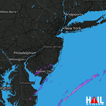 PHILADELPHIA (KDIX) RADAR

