This weather event on November 8, 2025 includes:
2 states
19 counties,
17 cities,
and 51 zip codes.
There were 3313 total properties that were impacted and have possible damage.
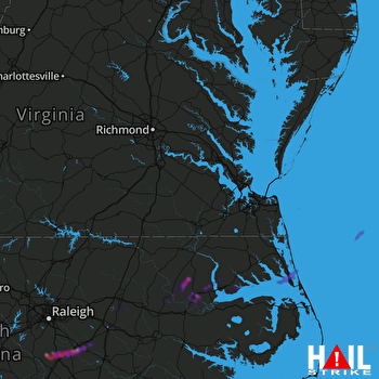 NORFOLK/RICH (KAKQ) RADAR
States Impacted By Hail On November 8, 2025
North Carolina
·
Virginia
Counties Impacted By Hail On November 8, 2025
Bertie, NC
·
Camden, NC
·
Chowan, NC
·
Currituck, NC
·
Dare, NC
·
Edgecombe, NC
·
Gates, NC
·
Halifax, NC
·
Harnett, NC
·
Hertford, NC
·
Johnston, NC
·
Martin, NC
·
Nash, NC
·
Pasquotank, NC
·
Perquimans, NC
·
Wilson, NC
·
Isle of Wight, VA
·
Southampton, VA
·
Virginia Beach, VA
Cities Impacted By Hail On November 8, 2025
Coats, NC
·
Duck, NC
·
Edenton, NC
·
Four Oaks, NC
·
Hamilton, NC
·
Kenly, NC
·
Lewiston Woodville, NC
·
Micro, NC
·
Oak City, NC
·
Pine Level, NC
·
Rocky Mount, NC
·
Selma, NC
·
Sharpsburg, NC
·
Smithfield, NC
·
Tarboro, NC
·
Virginia Beach, VA
·
Windsor, NC
Zip Codes Impacted By Hail On November 8, 2025
23456
·
23851
·
23866
·
23888
·
27501
·
27504
·
27521
·
27524
·
27542
·
27555
·
27557
·
27568
·
27569
·
27576
·
27577
·
27801
·
27803
·
27805
·
27807
·
27809
·
27822
·
27829
·
27840
·
27843
·
27847
·
27849
·
27857
·
27874
·
27878
·
27880
·
27883
·
27886
·
27892
·
27909
·
27910
·
27919
·
27927
·
27932
·
27938
·
27939
·
27944
·
27946
·
27947
·
27965
·
27966
·
27974
·
27980
·
27924
·
27949
·
27957
·
27983

