This weather event on October 26, 2025 includes:
1 states
8 counties,
44 cities,
and 52 zip codes.
There were total properties that were impacted and have possible damage.
States Impacted By Hail On October 26, 2025
Florida
Counties Impacted By Hail On October 26, 2025
Brevard, FL
·
Indian River, FL
·
Lake, FL
·
Martin, FL
·
Orange, FL
·
Seminole, FL
·
St. Lucie, FL
·
Volusia, FL
Cities Impacted By Hail On October 26, 2025
Cape Canaveral, FL
·
Clarcona, FL
·
Clermont, FL
·
Cocoa, FL
·
Cocoa Beach, FL
·
Cocoa West, FL
·
Eustis, FL
·
Florida Ridge, FL
·
Fort Pierce North, FL
·
Groveland, FL
·
Horizon West, FL
·
Hutchinson Island South, FL
·
Indialantic, FL
·
Indian River Shores, FL
·
Jensen Beach, FL
·
Lake Butler, FL
·
Melbourne, FL
·
Melbourne Beach, FL
·
Merritt Island, FL
·
Mims, FL
·
Mount Dora, FL
·
Mount Plymouth, FL
·
Oak Ridge, FL
·
Ocean Breeze Park, FL
·
Ocoee, FL
·
Palm Shores, FL
·
Pine Hills, FL
·
Port Salerno, FL
·
Port St. John, FL
·
Rockledge, FL
·
Sewall's Point, FL
·
Sharpes, FL
·
Sorrento, FL
·
South Beach, FL
·
St. Lucie Village, FL
·
Stuart, FL
·
Tangerine, FL
·
Titusville, FL
·
Vero Beach, FL
·
Vero Beach South, FL
·
Viera East, FL
·
Viera West, FL
·
Winter Garden, FL
·
Zellwood, FL
Zip Codes Impacted By Hail On October 26, 2025
32726
·
32736
·
32754
·
32757
·
32771
·
32776
·
32780
·
32784
·
32798
·
32809
·
32811
·
32818
·
32819
·
32835
·
32839
·
32920
·
32922
·
32926
·
32927
·
32931
·
32934
·
32952
·
32953
·
32955
·
32962
·
32963
·
32968
·
33455
·
34705
·
34711
·
34715
·
34736
·
34737
·
34761
·
34786
·
34787
·
34945
·
34946
·
34949
·
34951
·
34957
·
34996
·
34997
·
32951
·
32940
·
32935
·
32796
·
32724
·
32712
·
32703
·
32168
·
32124
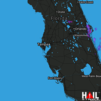 TAMPA (KTBW) RADAR

