This weather event on October 7, 2025 includes:
1 states
18 counties,
11 cities,
and 71 zip codes.
There were 2298 total properties that were impacted and have possible damage.
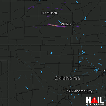 VANCE AFB (KVNX) RADAR
States Impacted By Hail On October 7, 2025
Kansas
Counties Impacted By Hail On October 7, 2025
Barton, KS
·
Butler, KS
·
Edwards, KS
·
Ellsworth, KS
·
Ford, KS
·
Hodgeman, KS
·
Kingman, KS
·
Kiowa, KS
·
Marion, KS
·
McPherson, KS
·
Pawnee, KS
·
Pratt, KS
·
Reno, KS
·
Rice, KS
·
Rush, KS
·
Sedgwick, KS
·
Stafford, KS
·
Sumner, KS
Cities Impacted By Hail On October 7, 2025
Alden, KS
·
Andover, KS
·
Augusta, KS
·
Cheney, KS
·
Garden Plain, KS
·
Goddard, KS
·
Goessel, KS
·
Kingman, KS
·
Moundridge, KS
·
Plevna, KS
·
Wichita, KS
Zip Codes Impacted By Hail On October 7, 2025
66861
·
67002
·
67010
·
67013
·
67025
·
67028
·
67035
·
67037
·
67042
·
67050
·
67052
·
67053
·
67063
·
67066
·
67068
·
67073
·
67107
·
67111
·
67114
·
67232
·
67428
·
67443
·
67444
·
67457
·
67459
·
67460
·
67464
·
67491
·
67501
·
67502
·
67510
·
67512
·
67514
·
67519
·
67522
·
67526
·
67530
·
67546
·
67547
·
67550
·
67552
·
67554
·
67559
·
67561
·
67563
·
67566
·
67567
·
67568
·
67570
·
67573
·
67574
·
67575
·
67576
·
67578
·
67579
·
67581
·
67583
·
67801
·
67876
·
67059
·
67118
·
67124
·
67133
·
67134
·
67144
·
67149
·
67209
·
67212
·
67216
·
67217
·
67230

