This weather event on October 6, 2025 includes:
2 states
6 counties,
49 cities,
and 52 zip codes.
There were total properties that were impacted and have possible damage.
States Impacted By Hail On October 6, 2025
Illinois
·
Michigan
Counties Impacted By Hail On October 6, 2025
Cook, IL
·
DuPage, IL
·
Lake, IL
·
Eaton, MI
·
Ogemaw, MI
·
Roscommon, MI
Cities Impacted By Hail On October 6, 2025
Arlington Heights, IL
·
Bellwood, IL
·
Berkeley, IL
·
Berwyn, IL
·
Broadview, IL
·
Brookfield, IL
·
Buffalo Grove, IL
·
Cicero, IL
·
Countryside, IL
·
Deer Park, IL
·
Elmhurst, IL
·
Forest Park, IL
·
Green Oaks, IL
·
Hillside, IL
·
Hinsdale, IL
·
Kildeer, IL
·
Knollwood, IL
·
La Grange, IL
·
La Grange Park, IL
·
Lake Bluff, IL
·
Lake Forest, IL
·
Lake Zurich, IL
·
Libertyville, IL
·
Long Grove, IL
·
Lupton, MI
·
Lyons, IL
·
Maywood, IL
·
McCook, IL
·
Melrose Park, IL
·
Mettawa, IL
·
Mulliken, MI
·
North Chicago, IL
·
Northlake, IL
·
North Riverside, IL
·
Oak Brook, IL
·
Oak Park, IL
·
Palatine, IL
·
Prospect Heights, IL
·
River Forest, IL
·
River Grove, IL
·
Riverside, IL
·
Rolling Meadows, IL
·
Rose City, MI
·
Stickney, IL
·
Stone Park, IL
·
Waukegan, IL
·
Westchester, IL
·
Western Springs, IL
·
Wheeling, IL
Zip Codes Impacted By Hail On October 6, 2025
48635
·
48651
·
48654
·
48656
·
48661
·
48761
·
48837
·
48861
·
60004
·
60005
·
60008
·
60010
·
60044
·
60045
·
60047
·
60048
·
60064
·
60067
·
60069
·
60070
·
60074
·
60085
·
60088
·
60089
·
60090
·
60104
·
60126
·
60130
·
60141
·
60153
·
60154
·
60155
·
60160
·
60162
·
60163
·
60164
·
60165
·
60171
·
60301
·
60302
·
60304
·
60305
·
60402
·
60513
·
60521
·
60523
·
60525
·
60526
·
60534
·
60546
·
60558
·
60804
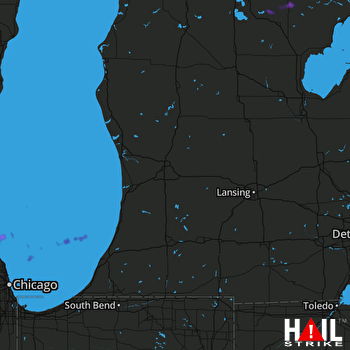 GRAND RAPIDS (KGRR) RADAR

