This weather event on September 26, 2025 includes:
4 states
32 counties,
19 cities,
and 73 zip codes.
There were 3300 total properties that were impacted and have possible damage.
States Impacted By Hail On September 26, 2025
Alabama
·
Georgia
·
North Carolina
·
Tennessee
Counties Impacted By Hail On September 26, 2025
Clay, AL
·
Cleburne, AL
·
DeKalb, AL
·
Jackson, AL
·
Lawrence, AL
·
Limestone, AL
·
Madison, AL
·
Morgan, AL
·
Randolph, AL
·
Tallapoosa, AL
·
Winston, AL
·
Bartow, GA
·
Carroll, GA
·
Cherokee, GA
·
Cobb, GA
·
Douglas, GA
·
Hall, GA
·
Haralson, GA
·
Lumpkin, GA
·
Union, GA
·
Walker, GA
·
Clay, NC
·
Bledsoe, TN
·
McMinn, TN
·
Meigs, TN
·
Monroe, TN
·
Morgan, TN
·
Rhea, TN
·
Roane, TN
·
Van Buren, TN
·
Warren, TN
·
White, TN
Cities Impacted By Hail On September 26, 2025
Athens, AL
·
Bowdon, GA
·
Coalfield, TN
·
Dayton, TN
·
Decatur, TN
·
Douglasville, GA
·
Flowery Branch, GA
·
Gainesville, GA
·
Hackneyville, AL
·
Hayesville, NC
·
Ider, AL
·
Kennesaw, GA
·
Meridianville, AL
·
Moores Mill, AL
·
Oakwood, GA
·
Ranburne, AL
·
Redstone Arsenal, AL
·
Sweetwater, TN
·
Triana, AL
Zip Codes Impacted By Hail On September 26, 2025
30064
·
30101
·
30108
·
30110
·
30127
·
30134
·
30135
·
30144
·
30152
·
30184
·
30187
·
30189
·
30501
·
30504
·
30512
·
30528
·
30542
·
30566
·
30707
·
30728
·
35010
·
35072
·
35540
·
35603
·
35611
·
35614
·
35619
·
35640
·
35650
·
35670
·
35673
·
35756
·
35759
·
35761
·
35773
·
35805
·
35806
·
35808
·
35810
·
35811
·
35824
·
35966
·
35978
·
35981
·
36251
·
36263
·
36264
·
36266
·
36273
·
36278
·
36280
·
37110
·
37303
·
37321
·
37329
·
37332
·
37367
·
37381
·
37385
·
37719
·
37748
·
37840
·
37874
·
38559
·
38579
·
38581
·
38583
·
28904
·
30102
·
30157
·
36255
·
37322
·
37826
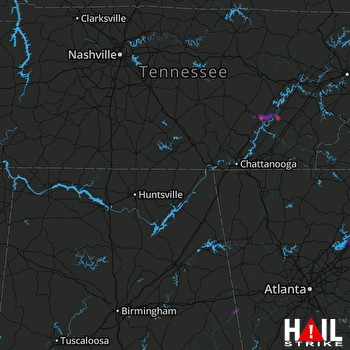 HUNTSVILLE (KHTX) RADAR

