This weather event on September 25, 2025 includes:
3 states
22 counties,
24 cities,
and 60 zip codes.
There were 206 total properties that were impacted and have possible damage.
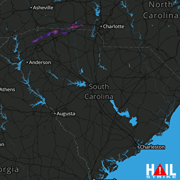 COLUMBIA (KCAE) RADAR
States Impacted By Hail On September 25, 2025
Georgia
·
North Carolina
·
South Carolina
Counties Impacted By Hail On September 25, 2025
Barrow, GA
·
Jackson, GA
·
Jenkins, GA
·
Screven, GA
·
Bladen, NC
·
Cleveland, NC
·
Columbus, NC
·
Gaston, NC
·
Moore, NC
·
Robeson, NC
·
Rutherford, NC
·
Aiken, SC
·
Calhoun, SC
·
Cherokee, SC
·
Chesterfield, SC
·
Greenville, SC
·
Lexington, SC
·
Oconee, SC
·
Pickens, SC
·
Richland, SC
·
Saluda, SC
·
Spartanburg, SC
Cities Impacted By Hail On September 25, 2025
Arial, SC
·
Bessemer City, NC
·
Campobello, SC
·
Cayce, SC
·
Cheraw, SC
·
Cliffside, NC
·
Earl, NC
·
Evergreen, NC
·
Fair Bluff, NC
·
Fingerville, SC
·
Foxfire, NC
·
Gaffney, SC
·
Gaston, SC
·
Gastonia, NC
·
Gramling, SC
·
Inman, SC
·
Jefferson, GA
·
Kings Mountain, NC
·
Light Oak, NC
·
Mayo, SC
·
Patterson Springs, NC
·
Shelby, NC
·
Swansea, SC
·
Travelers Rest, SC
Zip Codes Impacted By Hail On September 25, 2025
27281
·
28016
·
28021
·
28052
·
28073
·
28076
·
28086
·
28114
·
28139
·
28150
·
28152
·
28315
·
28320
·
28358
·
28369
·
28431
·
28433
·
28438
·
28439
·
28472
·
29006
·
29033
·
29053
·
29061
·
29070
·
29073
·
29123
·
29137
·
29138
·
29160
·
29172
·
29201
·
29203
·
29209
·
29212
·
29316
·
29322
·
29323
·
29330
·
29341
·
29349
·
29356
·
29520
·
29609
·
29613
·
29617
·
29640
·
29651
·
29661
·
29671
·
29687
·
29690
·
29693
·
30442
·
30467
·
30549
·
30680
·
29164
·
29338
·
29635

