This weather event on September 24, 2025 includes:
4 states
22 counties,
20 cities,
and 59 zip codes.
There were 7031 total properties that were impacted and have possible damage.
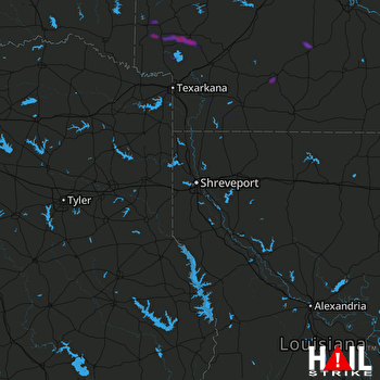 SHREVEPORT (KSHV) RADAR
States Impacted By Hail On September 24, 2025
Arkansas
·
Louisiana
·
Oklahoma
·
Texas
Counties Impacted By Hail On September 24, 2025
Columbia, AR
·
Dallas, AR
·
Garland, AR
·
Hempstead, AR
·
Hot Spring, AR
·
Howard, AR
·
Lafayette, AR
·
Little River, AR
·
Miller, AR
·
Montgomery, AR
·
Nevada, AR
·
Ouachita, AR
·
Sevier, AR
·
Union, AR
·
Bossier, LA
·
Caddo, LA
·
McCurtain, OK
·
Bowie, TX
·
Cass, TX
·
Harrison, TX
·
Marion, TX
·
Panola, TX
Cities Impacted By Hail On September 24, 2025
Bodcaw, AR
·
Camden, AR
·
Carthage, TX
·
Fordyce, AR
·
Fouke, AR
·
Greenwood, LA
·
Lakeview, LA
·
Lockesburg, AR
·
Louann, AR
·
Mineral Springs, AR
·
Nashville, AR
·
Ozan, AR
·
Rosston, AR
·
Shreveport, LA
·
Smackover, AR
·
Stephens, AR
·
Texarkana, AR
·
Texarkana, TX
·
Wake Village, TX
·
Yarborough Landing, AR
Zip Codes Impacted By Hail On September 24, 2025
71006
·
71007
·
71033
·
71047
·
71101
·
71104
·
71107
·
71108
·
71109
·
71118
·
71119
·
71129
·
71701
·
71725
·
71726
·
71740
·
71742
·
71751
·
71752
·
71753
·
71758
·
71762
·
71764
·
71832
·
71833
·
71835
·
71837
·
71839
·
71841
·
71842
·
71845
·
71846
·
71851
·
71852
·
71854
·
71855
·
71858
·
71859
·
71860
·
71861
·
71862
·
71929
·
71933
·
71943
·
74745
·
75501
·
75503
·
75563
·
75633
·
75639
·
75650
·
75656
·
75657
·
75661
·
75692
·
75602
·
71921
·
71822
·
71801

