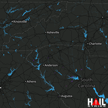
This weather event on September 20, 2025 includes:
4 states
26 counties,
25 cities,
and 61 zip codes.
There were 2343 total properties that were impacted and have possible damage.
States Impacted By Hail On September 20, 2025
Georgia
·
North Carolina
·
South Carolina
·
Tennessee
Counties Impacted By Hail On September 20, 2025
Franklin, GA
·
Hart, GA
·
Lumpkin, GA
·
Richmond, GA
·
Union, GA
·
Washington, GA
·
White, GA
·
Buncombe, NC
·
Henderson, NC
·
Abbeville, SC
·
Anderson, SC
·
Edgefield, SC
·
Fairfield, SC
·
Greenville, SC
·
Greenwood, SC
·
Kershaw, SC
·
Laurens, SC
·
Lexington, SC
·
Newberry, SC
·
Oconee, SC
·
Pickens, SC
·
Richland, SC
·
Saluda, SC
·
Spartanburg, SC
·
Union, SC
·
Sullivan, TN
Cities Impacted By Hail On September 20, 2025
Augusta-Richmond County consolidated government (balance), GA
·
Batesburg-Leesville, SC
·
Berea, SC
·
Clinton, SC
·
Dana, NC
·
Dentsville, SC
·
Dunean, SC
·
Gantt, SC
·
Greenville, SC
·
Greenwood, SC
·
Gumlog, GA
·
Hendersonville, NC
·
Judson, SC
·
Liberty, SC
·
Lowndesville, SC
·
Lugoff, SC
·
Mountain Home, NC
·
Murphys Estates, SC
·
Parker, SC
·
Piedmont, SC
·
Powdersville, SC
·
Taylors, SC
·
Westminster, SC
·
Winnsboro, SC
·
Winnsboro Mills, SC
Zip Codes Impacted By Hail On September 20, 2025
28731
·
28732
·
28792
·
28803
·
29016
·
29054
·
29070
·
29078
·
29108
·
29127
·
29129
·
29145
·
29178
·
29180
·
29203
·
29204
·
29209
·
29223
·
29322
·
29325
·
29349
·
29356
·
29379
·
29601
·
29605
·
29607
·
29609
·
29611
·
29617
·
29620
·
29628
·
29640
·
29642
·
29643
·
29649
·
29651
·
29653
·
29655
·
29657
·
29659
·
29661
·
29673
·
29678
·
29687
·
29690
·
29691
·
29693
·
29860
·
30512
·
30528
·
30553
·
30904
·
30906
·
30909
·
37617
·
37663
·
37686
·
31094
·
29832
·
29138
·
28791
 GREER (KGSP) RADAR

