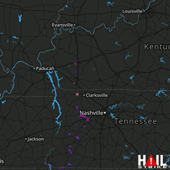
This weather event on September 19, 2025 includes:
4 states
28 counties,
13 cities,
and 74 zip codes.
There were 5069 total properties that were impacted and have possible damage.
States Impacted By Hail On September 19, 2025
Alabama
·
Kentucky
·
Mississippi
·
Tennessee
Counties Impacted By Hail On September 19, 2025
Colbert, AL
·
Lauderdale, AL
·
Lawrence, AL
·
Limestone, AL
·
Christian, KY
·
Fulton, KY
·
Hickman, KY
·
Hopkins, KY
·
Muhlenberg, KY
·
Trigg, KY
·
Carroll, TN
·
Cheatham, TN
·
Dickson, TN
·
Giles, TN
·
Hardin, TN
·
Henry, TN
·
Hickman, TN
·
Houston, TN
·
Humphreys, TN
·
Lawrence, TN
·
Lewis, TN
·
Maury, TN
·
McNairy, TN
·
Montgomery, TN
·
Perry, TN
·
Stewart, TN
·
Wayne, TN
·
Williamson, TN
Cities Impacted By Hail On September 19, 2025
Burns, TN
·
Clarksville, TN
·
Dickson, TN
·
Earlington, KY
·
Fairview, TN
·
Hohenwald, TN
·
LaFayette, KY
·
Madisonville, KY
·
Muscle Shoals, AL
·
Slayden, TN
·
St. Charles, KY
·
Summertown, TN
·
White Bluff, TN
Zip Codes Impacted By Hail On September 19, 2025
35610
·
35614
·
35616
·
35620
·
35633
·
35646
·
35647
·
35652
·
35661
·
35672
·
35674
·
35677
·
35739
·
37025
·
37029
·
37033
·
37036
·
37040
·
37042
·
37050
·
37051
·
37052
·
37055
·
37062
·
37082
·
37096
·
37097
·
37098
·
37137
·
37142
·
37165
·
37181
·
37187
·
37191
·
38201
·
38231
·
38236
·
38310
·
38326
·
38342
·
38344
·
38357
·
38365
·
38372
·
38376
·
38379
·
38450
·
38452
·
38456
·
38462
·
38463
·
38464
·
38471
·
38474
·
38478
·
38483
·
38485
·
38486
·
42041
·
42211
·
42217
·
42223
·
42232
·
42236
·
42240
·
42254
·
42344
·
42408
·
42410
·
42431
·
42442
·
42453
·
42464
·
37101
 FORT CAMPBELL (KHPX) RADAR

