This weather event on September 18, 2025 includes:
1 states
10 counties,
29 cities,
and 66 zip codes.
There were 130 total properties that were impacted and have possible damage.
States Impacted By Hail On September 18, 2025
Arizona
Counties Impacted By Hail On September 18, 2025
Coconino, AZ
·
Gila, AZ
·
Graham, AZ
·
La Paz, AZ
·
Maricopa, AZ
·
Mohave, AZ
·
Pima, AZ
·
Pinal, AZ
·
Yavapai, AZ
·
Yuma, AZ
Cities Impacted By Hail On September 18, 2025
Alamo Lake, AZ
·
Arlington, AZ
·
Bouse, AZ
·
Brenda, AZ
·
Central Heights-Midland City, AZ
·
Claypool, AZ
·
Coolidge, AZ
·
East Globe, AZ
·
Elephant Head, AZ
·
Gila Bend, AZ
·
Globe, AZ
·
Icehouse Canyon, AZ
·
Mayer, AZ
·
Mesa, AZ
·
Peoria, AZ
·
Phoenix, AZ
·
Prescott Valley, AZ
·
Queen Creek, AZ
·
Rincon Valley, AZ
·
Saddlebrooke, AZ
·
Salome, AZ
·
Six Shooter Canyon, AZ
·
Summerhaven, AZ
·
Tonto Basin, AZ
·
Tucson, AZ
·
Utting, AZ
·
Vail, AZ
·
Valencia West, AZ
·
Vicksburg, AZ
Zip Codes Impacted By Hail On September 18, 2025
85003
·
85004
·
85007
·
85029
·
85034
·
85040
·
85041
·
85053
·
85123
·
85128
·
85131
·
85132
·
85137
·
85142
·
85192
·
85208
·
85209
·
85212
·
85264
·
85320
·
85322
·
85325
·
85326
·
85332
·
85333
·
85337
·
85342
·
85344
·
85346
·
85347
·
85348
·
85352
·
85354
·
85357
·
85365
·
85501
·
85530
·
85539
·
85541
·
85544
·
85545
·
85550
·
85553
·
85602
·
85614
·
85619
·
85623
·
85629
·
85631
·
85634
·
85641
·
85645
·
85730
·
85736
·
85746
·
85747
·
85757
·
86024
·
86303
·
86305
·
86314
·
86333
·
86438
·
86315
·
85739
·
85215
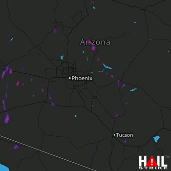 PHOENIX (KIWA) RADAR

