This weather event on September 17, 2025 includes:
4 states
24 counties,
23 cities,
and 78 zip codes.
There were 2005 total properties that were impacted and have possible damage.
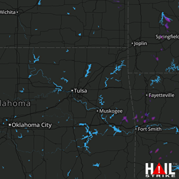 TULSA (KINX) RADAR
States Impacted By Hail On September 17, 2025
Arkansas
·
Kansas
·
Missouri
·
Oklahoma
Counties Impacted By Hail On September 17, 2025
Benton, AR
·
Carroll, AR
·
Crawford, AR
·
Franklin, AR
·
Johnson, AR
·
Logan, AR
·
Scott, AR
·
Washington, AR
·
Yell, AR
·
Bourbon, KS
·
Linn, KS
·
Barry, MO
·
Cedar, MO
·
Christian, MO
·
Dade, MO
·
Greene, MO
·
Lawrence, MO
·
Polk, MO
·
Stone, MO
·
Taney, MO
·
Adair, OK
·
McCurtain, OK
·
Pushmataha, OK
·
Sequoyah, OK
Cities Impacted By Hail On September 17, 2025
Akins, OK
·
Alma, AR
·
Aurora, MO
·
Brushy, OK
·
Butterfield, MO
·
Cedarville, AR
·
Chester, AR
·
Dadeville, MO
·
Elkins, AR
·
Fayetteville, AR
·
Greasy, OK
·
Highfill, AR
·
Mound City, KS
·
Mountainburg, AR
·
Pinhook Corner, OK
·
Reeds Spring, MO
·
Rudy, AR
·
Sallisaw, OK
·
Short, OK
·
Stoney Point, OK
·
Tontitown, AR
·
Verona, MO
·
Waldron, AR
Zip Codes Impacted By Hail On September 17, 2025
65601
·
65604
·
65605
·
65623
·
65625
·
65629
·
65635
·
65646
·
65649
·
65653
·
65705
·
65707
·
65708
·
65712
·
65721
·
65723
·
65734
·
65737
·
65759
·
65769
·
65770
·
65785
·
66010
·
66056
·
66075
·
66716
·
66738
·
66754
·
66767
·
66769
·
66779
·
72616
·
72638
·
72701
·
72704
·
72712
·
72717
·
72727
·
72729
·
72734
·
72762
·
72774
·
72827
·
72828
·
72830
·
72833
·
72838
·
72841
·
72852
·
72854
·
72857
·
72921
·
72927
·
72932
·
72934
·
72946
·
72947
·
72948
·
72949
·
72950
·
72952
·
72955
·
72956
·
72958
·
74523
·
74543
·
74558
·
74562
·
74567
·
74764
·
74766
·
74931
·
74945
·
74948
·
74955
·
74962
·
66701
·
65753

