This weather event on September 14, 2025 includes:
2 states
16 counties,
18 cities,
and 56 zip codes.
There were 2684 total properties that were impacted and have possible damage.
States Impacted By Hail On September 14, 2025
Indiana
·
Kentucky
Counties Impacted By Hail On September 14, 2025
Clark, IN
·
Crawford, IN
·
Floyd, IN
·
Harrison, IN
·
Jackson, IN
·
Perry, IN
·
Scott, IN
·
Washington, IN
·
Breckinridge, KY
·
Bullitt, KY
·
Daviess, KY
·
Hancock, KY
·
Hardin, KY
·
Jefferson, KY
·
Meade, KY
·
Ohio, KY
Cities Impacted By Hail On September 14, 2025
Alton, IN
·
Austin, IN
·
Clarksville, IN
·
Cloverport, KY
·
Crothersville, IN
·
Elizabeth, IN
·
Fort Knox, KY
·
Lanesville, IN
·
Louisville, KY
·
Muldraugh, KY
·
New Albany, IN
·
Palmyra, IN
·
Radcliff, KY
·
Salem, IN
·
Scottsburg, IN
·
Shively, KY
·
Vine Grove, KY
·
West Point, KY
Zip Codes Impacted By Hail On September 14, 2025
40109
·
40111
·
40119
·
40121
·
40143
·
40146
·
40155
·
40157
·
40160
·
40161
·
40165
·
40170
·
40171
·
40175
·
40176
·
40177
·
40203
·
40208
·
40210
·
40211
·
40212
·
40213
·
40214
·
40215
·
40216
·
40258
·
40272
·
42343
·
42348
·
42368
·
42378
·
47102
·
47111
·
47112
·
47115
·
47117
·
47124
·
47126
·
47129
·
47135
·
47136
·
47137
·
47141
·
47150
·
47161
·
47163
·
47165
·
47167
·
47170
·
47177
·
47229
·
47520
·
47574
·
40104
·
40162
·
47164
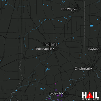 INDIANAPOLIS (KIND) RADAR

