This weather event on September 13, 2025 includes:
2 states
22 counties,
31 cities,
and 70 zip codes.
There were 5180 total properties that were impacted and have possible damage.
States Impacted By Hail On September 13, 2025
Illinois
·
Indiana
Counties Impacted By Hail On September 13, 2025
Kankakee, IL
·
Benton, IN
·
Boone, IN
·
Carroll, IN
·
Cass, IN
·
Clinton, IN
·
Fountain, IN
·
Fulton, IN
·
Hendricks, IN
·
Henry, IN
·
Jasper, IN
·
Lake, IN
·
Marshall, IN
·
Montgomery, IN
·
Morgan, IN
·
Newton, IN
·
Pulaski, IN
·
Putnam, IN
·
Starke, IN
·
Tippecanoe, IN
·
Warren, IN
·
White, IN
Cities Impacted By Hail On September 13, 2025
Attica, IN
·
Avon, IN
·
Bass Lake, IN
·
Battle Ground, IN
·
Clarks Hill, IN
·
Colfax, IN
·
Collegeville, IN
·
Crawfordsville, IN
·
Danville, IN
·
Knox, IN
·
Lake Holiday, IN
·
Lake Village, IN
·
Monterey, IN
·
Monticello, IN
·
Montmorenci, IN
·
Mooresville, IN
·
Mount Ayr, IN
·
New Market, IN
·
New Richmond, IN
·
Otterbein, IN
·
Pittsboro, IN
·
Plainfield, IN
·
Remington, IN
·
Rensselaer, IN
·
Schneider, IN
·
Shadeland, IN
·
Van Bibber Lake, IN
·
West Point, IN
·
Winamac, IN
·
Wolcott, IN
·
Yeoman, IN
Zip Codes Impacted By Hail On September 13, 2025
46035
·
46041
·
46052
·
46105
·
46118
·
46122
·
46123
·
46147
·
46148
·
46149
·
46158
·
46167
·
46168
·
46172
·
46175
·
46310
·
46349
·
46356
·
46376
·
46379
·
46501
·
46534
·
46563
·
46570
·
46923
·
46939
·
46947
·
46950
·
46960
·
46975
·
46978
·
46985
·
46996
·
47384
·
47905
·
47906
·
47909
·
47918
·
47920
·
47922
·
47923
·
47929
·
47930
·
47933
·
47943
·
47944
·
47948
·
47954
·
47955
·
47959
·
47960
·
47963
·
47964
·
47965
·
47967
·
47970
·
47971
·
47978
·
47980
·
47981
·
47989
·
47990
·
47992
·
47995
·
60940
·
60954
·
47997
·
47977
·
46511
·
46135
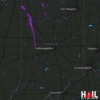 INDIANAPOLIS (KIND) RADAR

