This weather event on September 9, 2025 includes:
3 states
28 counties,
11 cities,
and 71 zip codes.
There were 3993 total properties that were impacted and have possible damage.
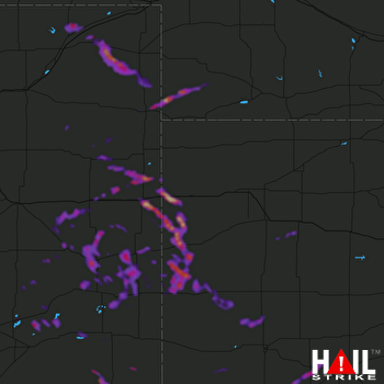 GOODLAND (KGLD) RADAR
States Impacted By Hail On September 9, 2025
Colorado
·
Kansas
·
Nebraska
Counties Impacted By Hail On September 9, 2025
Baca, CO
·
Bent, CO
·
Cheyenne, CO
·
Crowley, CO
·
Kiowa, CO
·
Kit Carson, CO
·
Lincoln, CO
·
Logan, CO
·
Morgan, CO
·
Otero, CO
·
Phillips, CO
·
Prowers, CO
·
Washington, CO
·
Yuma, CO
·
Finney, KS
·
Ford, KS
·
Gove, KS
·
Gray, KS
·
Greeley, KS
·
Hamilton, KS
·
Kearny, KS
·
Scott, KS
·
Sherman, KS
·
Wallace, KS
·
Wichita, KS
·
Chase, NE
·
Cheyenne, NE
·
Dundy, NE
Cities Impacted By Hail On September 9, 2025
Brandon, CO
·
Burlington, CO
·
Cimarron, KS
·
Greeley County unified government (balance), KS
·
Hasty, CO
·
Haxtun, CO
·
Joes, CO
·
Kanorado, KS
·
Kirk, CO
·
Kit Carson, CO
·
Sidney, NE
Zip Codes Impacted By Hail On September 9, 2025
67735
·
67736
·
67737
·
67738
·
67741
·
67748
·
67758
·
67762
·
67801
·
67835
·
67837
·
67838
·
67846
·
67851
·
67853
·
67860
·
67861
·
67867
·
67878
·
67879
·
67880
·
69021
·
69027
·
69030
·
69041
·
69162
·
80720
·
80723
·
80727
·
80728
·
80731
·
80734
·
80735
·
80736
·
80745
·
80747
·
80758
·
80759
·
80802
·
80804
·
80805
·
80807
·
80810
·
80812
·
80815
·
80821
·
80822
·
80823
·
80824
·
80825
·
80834
·
80836
·
80861
·
80862
·
81021
·
81036
·
81041
·
81044
·
81045
·
81050
·
81052
·
81057
·
81063
·
81071
·
81073
·
81076
·
81084
·
81090
·
67871
·
69045
·
81054

