This weather event on September 3, 2025 includes:
4 states
20 counties,
14 cities,
and 54 zip codes.
There were 1126 total properties that were impacted and have possible damage.
States Impacted By Hail On September 3, 2025
Illinois
·
Indiana
·
Kentucky
·
Missouri
Counties Impacted By Hail On September 3, 2025
Gallatin, IL
·
Jackson, IL
·
Perry, IL
·
Randolph, IL
·
Posey, IN
·
Spencer, IN
·
Vanderburgh, IN
·
Warrick, IN
·
Breckinridge, KY
·
Butler, KY
·
Daviess, KY
·
Grayson, KY
·
Hancock, KY
·
Henderson, KY
·
McLean, KY
·
Ohio, KY
·
Jefferson, MO
·
Ste. Genevieve, MO
·
St. Francois, MO
·
Washington, MO
Cities Impacted By Hail On September 3, 2025
Chester, IL
·
Equality, IL
·
Evansville, IN
·
Farmington, MO
·
Hatfield, IN
·
Henderson, KY
·
Leadington, MO
·
Masonville, KY
·
Newburgh, IN
·
Owensboro, KY
·
Park Hills, MO
·
Rockport, IN
·
Spottsville, KY
·
Whitesville, KY
Zip Codes Impacted By Hail On September 3, 2025
40119
·
40143
·
40144
·
42261
·
42301
·
42303
·
42320
·
42327
·
42328
·
42333
·
42343
·
42347
·
42348
·
42349
·
42351
·
42352
·
42355
·
42361
·
42366
·
42369
·
42376
·
42378
·
42406
·
42420
·
42451
·
42458
·
42721
·
47601
·
47610
·
47611
·
47615
·
47630
·
47634
·
47635
·
47638
·
47711
·
47712
·
47713
·
47714
·
47715
·
47720
·
62233
·
62832
·
62934
·
62954
·
62994
·
63020
·
63030
·
63601
·
63626
·
63630
·
63640
·
63674
·
47620
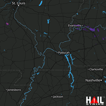 PADUCAH (KPAH) RADAR

