This weather event on August 29, 2025 includes:
1 states
18 counties,
19 cities,
and 54 zip codes.
There were 14 total properties that were impacted and have possible damage.
States Impacted By Hail On August 29, 2025
Florida
Counties Impacted By Hail On August 29, 2025
Brevard, FL
·
Broward, FL
·
Collier, FL
·
DeSoto, FL
·
Dixie, FL
·
Glades, FL
·
Hendry, FL
·
Highlands, FL
·
Lake, FL
·
Levy, FL
·
Marion, FL
·
Martin, FL
·
Okeechobee, FL
·
Osceola, FL
·
Palm Beach, FL
·
Polk, FL
·
Putnam, FL
·
Volusia, FL
Cities Impacted By Hail On August 29, 2025
Andrews, FL
·
Bronson, FL
·
Celebration, FL
·
Chiefland, FL
·
Clewiston, FL
·
Cross City, FL
·
DeLand, FL
·
East Bronson, FL
·
Immokalee, FL
·
Kissimmee, FL
·
Lake Alfred, FL
·
Lake Helen, FL
·
Leesburg, FL
·
Manatee Road, FL
·
Montura, FL
·
Morriston, FL
·
Ocala, FL
·
Winter Haven, FL
·
Yalaha, FL
Zip Codes Impacted By Hail On August 29, 2025
32124
·
32134
·
32139
·
32168
·
32621
·
32625
·
32626
·
32628
·
32668
·
32680
·
32696
·
32724
·
32744
·
32754
·
32764
·
32940
·
32948
·
33440
·
33471
·
33478
·
33809
·
33848
·
33850
·
33852
·
33857
·
33868
·
33881
·
33960
·
34141
·
34142
·
34266
·
34432
·
34471
·
34473
·
34474
·
34476
·
34481
·
34482
·
34488
·
34714
·
34739
·
34741
·
34744
·
34746
·
34747
·
34748
·
34759
·
34771
·
34772
·
34773
·
34797
·
34972
·
34974
·
34997
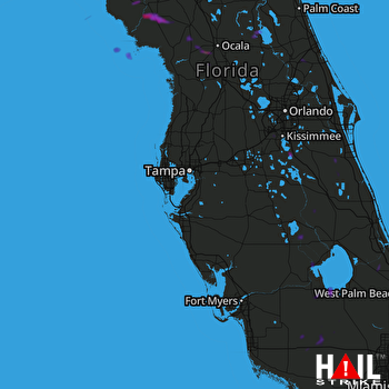 TAMPA (KTBW) RADAR

