This weather event on August 28, 2025 includes:
2 states
31 counties,
24 cities,
and 78 zip codes.
There were 886 total properties that were impacted and have possible damage.
States Impacted By Hail On August 28, 2025
Oklahoma
·
Texas
Counties Impacted By Hail On August 28, 2025
Comanche, OK
·
Jefferson, OK
·
Johnston, OK
·
Love, OK
·
Pontotoc, OK
·
Seminole, OK
·
Tillman, OK
·
Archer, TX
·
Baylor, TX
·
Childress, TX
·
Clay, TX
·
Collin, TX
·
Cooke, TX
·
Cottle, TX
·
Denton, TX
·
Grayson, TX
·
Hall, TX
·
Hardeman, TX
·
Haskell, TX
·
Jack, TX
·
King, TX
·
Knox, TX
·
Montague, TX
·
Motley, TX
·
Palo Pinto, TX
·
Stonewall, TX
·
Throckmorton, TX
·
Wichita, TX
·
Wilbarger, TX
·
Wise, TX
·
Young, TX
Cities Impacted By Hail On August 28, 2025
Ada, OK
·
Aubrey, TX
·
Byng, OK
·
Celina, TX
·
Decatur, TX
·
Denison, TX
·
Denton, TX
·
Gainesville, TX
·
Gunter, TX
·
Iowa Park, TX
·
Lindsay, TX
·
Nocona, TX
·
Nocona Hills, TX
·
Pilot Point, TX
·
Pottsboro, TX
·
Sadler, TX
·
Scotland, TX
·
Sherman, TX
·
Southmayd, TX
·
Thackerville, OK
·
Valley View, TX
·
Vernon, TX
·
Whitesboro, TX
·
Windthorst, TX
Zip Codes Impacted By Hail On August 28, 2025
73448
·
73459
·
73460
·
73527
·
73530
·
73540
·
73542
·
73546
·
73569
·
74820
·
74849
·
75009
·
75020
·
75021
·
75058
·
75076
·
75078
·
75090
·
75092
·
75459
·
76073
·
76201
·
76205
·
76207
·
76208
·
76209
·
76227
·
76228
·
76230
·
76233
·
76234
·
76238
·
76239
·
76240
·
76249
·
76250
·
76252
·
76255
·
76258
·
76259
·
76261
·
76263
·
76264
·
76265
·
76266
·
76268
·
76271
·
76272
·
76273
·
76310
·
76360
·
76365
·
76367
·
76370
·
76372
·
76374
·
76379
·
76380
·
76384
·
76389
·
76426
·
76449
·
76475
·
76486
·
79201
·
79227
·
79234
·
79236
·
79244
·
79252
·
79259
·
79502
·
79539
·
79544
·
79547
·
79248
·
76458
·
76225
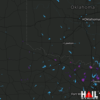 ALTUS AFB (KFDR) RADAR

