This weather event on August 22, 2025 includes:
3 states
27 counties,
18 cities,
and 61 zip codes.
There were 12882 total properties that were impacted and have possible damage.
States Impacted By Hail On August 22, 2025
Florida
·
Georgia
·
South Carolina
Counties Impacted By Hail On August 22, 2025
Baker, FL
·
Clay, FL
·
Duval, FL
·
Madison, FL
·
Nassau, FL
·
Putnam, FL
·
St. Johns, FL
·
Volusia, FL
·
Appling, GA
·
Brantley, GA
·
Brooks, GA
·
Bryan, GA
·
Bulloch, GA
·
Camden, GA
·
Charlton, GA
·
Chatham, GA
·
Clinch, GA
·
Effingham, GA
·
Liberty, GA
·
Long, GA
·
Lowndes, GA
·
McIntosh, GA
·
Pierce, GA
·
Tattnall, GA
·
Ware, GA
·
Wayne, GA
·
Jasper, SC
Cities Impacted By Hail On August 22, 2025
Callahan, FL
·
Daytona Beach, FL
·
Fort Stewart, GA
·
Fruit Cove, FL
·
Gumbranch, GA
·
Hardeeville, SC
·
Hinesville, GA
·
Jacksonville, FL
·
Kingsland, GA
·
Middleburg, FL
·
Nassau Village-Ratliff, FL
·
Ormond Beach, FL
·
Ponce Inlet, FL
·
Port Orange, FL
·
Savannah, GA
·
St. Marys, GA
·
Valdosta, GA
·
Yulee, FL
Zip Codes Impacted By Hail On August 22, 2025
29922
·
29927
·
29934
·
29936
·
29943
·
30436
·
30453
·
31302
·
31308
·
31312
·
31313
·
31314
·
31316
·
31322
·
31329
·
31331
·
31503
·
31516
·
31542
·
31543
·
31546
·
31547
·
31548
·
31558
·
31560
·
31562
·
31563
·
31601
·
31643
·
32009
·
32011
·
32034
·
32040
·
32043
·
32046
·
32068
·
32087
·
32097
·
32117
·
32127
·
32140
·
32174
·
32208
·
32209
·
32211
·
32218
·
32219
·
32220
·
32224
·
32225
·
32226
·
32234
·
32246
·
32250
·
32254
·
32258
·
32259
·
32277
·
32331
·
32340
·
32656
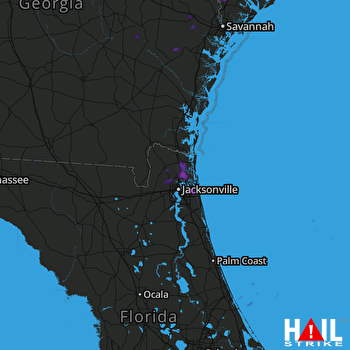 JACKSONVILLE (KJAX) RADAR

