This weather event on August 21, 2025 includes:
1 states
25 counties,
22 cities,
and 75 zip codes.
There were total properties that were impacted and have possible damage.
States Impacted By Hail On August 21, 2025
Texas
Counties Impacted By Hail On August 21, 2025
Atascosa, TX
·
Bexar, TX
·
Blanco, TX
·
Brewster, TX
·
Crockett, TX
·
Dimmit, TX
·
Duval, TX
·
Frio, TX
·
Hays, TX
·
Karnes, TX
·
Kendall, TX
·
La Salle, TX
·
Live Oak, TX
·
Llano, TX
·
Mason, TX
·
Maverick, TX
·
McCulloch, TX
·
McMullen, TX
·
Menard, TX
·
San Saba, TX
·
Schleicher, TX
·
Val Verde, TX
·
Webb, TX
·
Wilson, TX
·
Zavala, TX
Cities Impacted By Hail On August 21, 2025
Bonanza Hills, TX
·
Botines, TX
·
Cross Mountain, TX
·
El Indio, TX
·
Elmendorf, TX
·
Falls City, TX
·
Floresville, TX
·
Four Points, TX
·
Freer, TX
·
Grey Forest, TX
·
Helotes, TX
·
Laredo, TX
·
Leming, TX
·
Llano, TX
·
Los Corralitos, TX
·
Los Veteranos II, TX
·
Poth, TX
·
Round Mountain, TX
·
Somerset, TX
·
Sunset Acres, TX
·
Three Rivers, TX
·
Woodcreek, TX
Zip Codes Impacted By Hail On August 21, 2025
76820
·
76825
·
76832
·
76841
·
76842
·
76856
·
76859
·
76869
·
76877
·
76885
·
76887
·
76935
·
76936
·
76943
·
76950
·
78002
·
78004
·
78005
·
78006
·
78008
·
78012
·
78014
·
78019
·
78022
·
78023
·
78027
·
78041
·
78044
·
78045
·
78050
·
78061
·
78064
·
78065
·
78069
·
78071
·
78072
·
78073
·
78075
·
78101
·
78112
·
78113
·
78114
·
78117
·
78118
·
78121
·
78147
·
78160
·
78161
·
78223
·
78224
·
78255
·
78263
·
78264
·
78341
·
78344
·
78357
·
78371
·
78384
·
78619
·
78620
·
78636
·
78643
·
78663
·
78676
·
78829
·
78836
·
78837
·
78839
·
78840
·
78852
·
78860
·
78871
·
78834
·
78606
·
78017
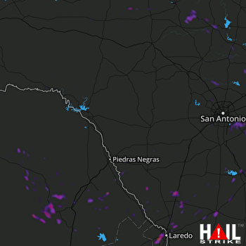 LAUGHLIN AFB (KDFX) RADAR

