This weather event on August 19, 2025 includes:
3 states
30 counties,
9 cities,
and 72 zip codes.
There were 367 total properties that were impacted and have possible damage.
States Impacted By Hail On August 19, 2025
New Mexico
·
Oklahoma
·
Texas
Counties Impacted By Hail On August 19, 2025
Roosevelt, NM
·
Beaver, OK
·
Ellis, OK
·
Roger Mills, OK
·
Bailey, TX
·
Carson, TX
·
Castro, TX
·
Cochran, TX
·
Crosby, TX
·
Deaf Smith, TX
·
Donley, TX
·
Gray, TX
·
Hale, TX
·
Hansford, TX
·
Hartley, TX
·
Hemphill, TX
·
Hockley, TX
·
Hutchinson, TX
·
Lipscomb, TX
·
Lubbock, TX
·
Lynn, TX
·
Moore, TX
·
Ochiltree, TX
·
Potter, TX
·
Randall, TX
·
Roberts, TX
·
Sherman, TX
·
Swisher, TX
·
Terry, TX
·
Yoakum, TX
Cities Impacted By Hail On August 19, 2025
Amarillo, TX
·
Hale Center, TX
·
Higgins, TX
·
Levelland, TX
·
Lipscomb, TX
·
Lubbock, TX
·
Perryton, TX
·
Slaton, TX
·
Stinnett, TX
Zip Codes Impacted By Hail On August 19, 2025
73628
·
73638
·
73642
·
73660
·
73832
·
73840
·
73843
·
73848
·
73858
·
79005
·
79007
·
79014
·
79015
·
79018
·
79029
·
79033
·
79034
·
79036
·
79039
·
79040
·
79041
·
79042
·
79044
·
79045
·
79046
·
79052
·
79056
·
79058
·
79059
·
79063
·
79065
·
79068
·
79070
·
79072
·
79080
·
79081
·
79083
·
79084
·
79086
·
79088
·
79091
·
79093
·
79097
·
79098
·
79104
·
79107
·
79108
·
79111
·
79118
·
79119
·
79226
·
79316
·
79336
·
79344
·
79345
·
79347
·
79355
·
79357
·
79363
·
79364
·
79367
·
79371
·
79376
·
79379
·
79381
·
79407
·
79410
·
79414
·
79415
·
79416
·
79424
·
88130
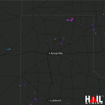 AMARILLO (KAMA) RADAR

