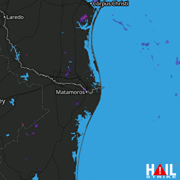
This weather event on August 19, 2025 includes:
1 states
13 counties,
30 cities,
and 38 zip codes.
There were 9419 total properties that were impacted and have possible damage.
States Impacted By Hail On August 19, 2025
Texas
Counties Impacted By Hail On August 19, 2025
Brooks, TX
·
Cameron, TX
·
Duval, TX
·
Hidalgo, TX
·
Jim Hogg, TX
·
Jim Wells, TX
·
Kenedy, TX
·
Kleberg, TX
·
Nueces, TX
·
San Patricio, TX
·
Starr, TX
·
Willacy, TX
·
Zapata, TX
Cities Impacted By Hail On August 19, 2025
Alamo, TX
·
Amada Acres, TX
·
Brownsville, TX
·
Chaparrito, TX
·
Concepcion, TX
·
Corpus Christi, TX
·
Donna, TX
·
Edcouch, TX
·
El Refugio, TX
·
Elsa, TX
·
Gregory, TX
·
Ingleside, TX
·
Ingleside on the Bay, TX
·
La Blanca, TX
·
La Casita, TX
·
Laguna Seca, TX
·
La Puerta, TX
·
Lasara, TX
·
La Villa, TX
·
Linn, TX
·
Midway North, TX
·
Mila Doce, TX
·
Monte Alto, TX
·
Olivarez, TX
·
Portland, TX
·
San Juan, TX
·
San Pedro, TX
·
South Alamo, TX
·
Weslaco, TX
·
Yznaga, TX
Zip Codes Impacted By Hail On August 19, 2025
78336
·
78343
·
78349
·
78353
·
78359
·
78361
·
78362
·
78374
·
78375
·
78376
·
78379
·
78385
·
78390
·
78415
·
78516
·
78520
·
78521
·
78526
·
78537
·
78541
·
78542
·
78543
·
78558
·
78561
·
78562
·
78564
·
78570
·
78575
·
78577
·
78580
·
78582
·
78584
·
78586
·
78589
·
78593
·
78596
·
78538
·
78569
 BROWNSVILLE (KBRO) RADAR

