This weather event on August 19, 2025 includes:
2 states
21 counties,
13 cities,
and 60 zip codes.
There were total properties that were impacted and have possible damage.
States Impacted By Hail On August 19, 2025
Kansas
·
Missouri
Counties Impacted By Hail On August 19, 2025
Allen, KS
·
Anderson, KS
·
Bourbon, KS
·
Coffey, KS
·
Dickinson, KS
·
Elk, KS
·
Greenwood, KS
·
Linn, KS
·
Miami, KS
·
Mitchell, KS
·
Morris, KS
·
Osage, KS
·
Saline, KS
·
Smith, KS
·
Barton, MO
·
Bates, MO
·
Cass, MO
·
Cedar, MO
·
Henry, MO
·
Johnson, MO
·
Vernon, MO
Cities Impacted By Hail On August 19, 2025
Amsterdam, MO
·
Blairstown, MO
·
Deerfield, MO
·
El Dorado Springs, MO
·
Hume, MO
·
Liberal, MO
·
Mapleton, KS
·
Milo, MO
·
Nevada, MO
·
New Strawn, KS
·
Prescott, KS
·
Salina, KS
·
Welda, KS
Zip Codes Impacted By Hail On August 19, 2025
64040
·
64722
·
64723
·
64724
·
64726
·
64728
·
64730
·
64735
·
64739
·
64741
·
64744
·
64747
·
64752
·
64762
·
64769
·
64770
·
64771
·
64772
·
64778
·
64779
·
64780
·
64784
·
64788
·
64790
·
66014
·
66015
·
66032
·
66040
·
66056
·
66071
·
66072
·
66075
·
66080
·
66091
·
66093
·
66738
·
66749
·
66754
·
66767
·
66769
·
66779
·
66839
·
66856
·
66868
·
66872
·
66952
·
67045
·
67047
·
67122
·
67137
·
67352
·
67401
·
67410
·
67420
·
67446
·
67449
·
67480
·
64733
·
64767
·
67349
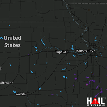 TOPEKA (KTWX) RADAR

