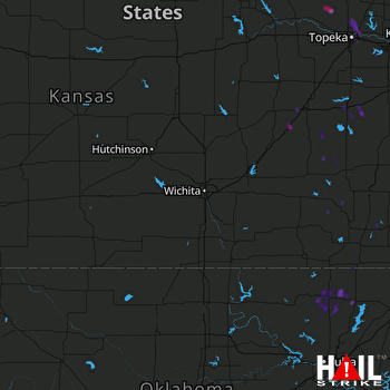
This weather event on August 19, 2025 includes:
2 states
27 counties,
15 cities,
and 88 zip codes.
There were 34 total properties that were impacted and have possible damage.
States Impacted By Hail On August 19, 2025
Kansas
·
Oklahoma
Counties Impacted By Hail On August 19, 2025
Anderson, KS
·
Chase, KS
·
Chautauqua, KS
·
Clark, KS
·
Coffey, KS
·
Cowley, KS
·
Douglas, KS
·
Elk, KS
·
Franklin, KS
·
Greenwood, KS
·
Jackson, KS
·
Jefferson, KS
·
Labette, KS
·
Lyon, KS
·
McPherson, KS
·
Montgomery, KS
·
Neosho, KS
·
Osage, KS
·
Pratt, KS
·
Shawnee, KS
·
Wilson, KS
·
Woodson, KS
·
Nowata, OK
·
Osage, OK
·
Pawnee, OK
·
Washington, OK
·
Woods, OK
Cities Impacted By Hail On August 19, 2025
Barnsdall, OK
·
Bartlesville, OK
·
Caney, KS
·
Coffeyville, KS
·
Dewey, OK
·
Emporia, KS
·
Grantville, KS
·
Hoyt, KS
·
Kincaid, KS
·
Nowata, OK
·
Ochelata, OK
·
Ottawa, KS
·
Topeka, KS
·
Virgil, KS
·
Waverly, KS
Zip Codes Impacted By Hail On August 19, 2025
66032
·
66039
·
66047
·
66067
·
66076
·
66079
·
66093
·
66409
·
66414
·
66418
·
66422
·
66429
·
66451
·
66509
·
66510
·
66512
·
66524
·
66537
·
66542
·
66603
·
66605
·
66607
·
66608
·
66609
·
66616
·
66617
·
66618
·
66714
·
66736
·
66740
·
66776
·
66783
·
66801
·
66830
·
66833
·
66839
·
66845
·
66852
·
66853
·
66854
·
66856
·
66860
·
66864
·
66865
·
66868
·
66870
·
66871
·
67005
·
67028
·
67045
·
67047
·
67124
·
67134
·
67301
·
67332
·
67333
·
67335
·
67337
·
67341
·
67346
·
67347
·
67349
·
67352
·
67357
·
67361
·
67491
·
67865
·
73717
·
74002
·
74003
·
74006
·
74022
·
74027
·
74029
·
74048
·
74051
·
74058
·
74061
·
74070
·
74072
·
74083
·
74637
·
74650
·
66078
·
66440
·
67023
·
67336
·
67360
 WICHITA (KICT) RADAR

