This weather event on August 17, 2025 includes:
4 states
42 counties,
56 cities,
and 174 zip codes.
There were 244 total properties that were impacted and have possible damage.
States Impacted By Hail On August 17, 2025
Iowa
·
Illinois
·
Missouri
·
Wisconsin
Counties Impacted By Hail On August 17, 2025
Benton, IA
·
Black Hawk, IA
·
Bremer, IA
·
Buchanan, IA
·
Butler, IA
·
Cedar, IA
·
Clayton, IA
·
Clinton, IA
·
Delaware, IA
·
Des Moines, IA
·
Dubuque, IA
·
Fayette, IA
·
Grundy, IA
·
Jackson, IA
·
Johnson, IA
·
Jones, IA
·
Linn, IA
·
Muscatine, IA
·
Scott, IA
·
Adams, IL
·
Bureau, IL
·
Carroll, IL
·
Ford, IL
·
Greene, IL
·
Hancock, IL
·
Henderson, IL
·
Henry, IL
·
LaSalle, IL
·
Lee, IL
·
Livingston, IL
·
Marshall, IL
·
McLean, IL
·
Pike, IL
·
Rock Island, IL
·
Scott, IL
·
Whiteside, IL
·
Marion, MO
·
Ralls, MO
·
Grant, WI
·
Juneau, WI
·
Sauk, WI
·
Vernon, WI
Cities Impacted By Hail On August 17, 2025
Anamosa, IA
·
Aurora, IA
·
Barry, IL
·
Baylis, IL
·
Bertram, IA
·
Bettendorf, IA
·
Burlington, IA
·
Carbon Cliff, IL
·
Center Junction, IA
·
Coggon, IA
·
Davenport, IA
·
Dike, IA
·
Donahue, IA
·
Dyersville, IA
·
East Moline, IL
·
Eldridge, IA
·
Gibson City, IL
·
Griggsville, IL
·
Gulf Port, IL
·
Hampton, IL
·
Hannibal, MO
·
Hillsboro, WI
·
Hollowayville, IL
·
Hudson, IA
·
Hull, IL
·
Kangley, IL
·
Kinderhook, IL
·
Le Claire, IA
·
Leonore, IL
·
Lostant, IL
·
Lost Nation, IA
·
Milton, IL
·
Moline, IL
·
Monticello, IA
·
Morley, IA
·
Mount Hope, WI
·
Oxford Junction, IA
·
Palmyra, MO
·
Panorama Park, IA
·
Payson, IL
·
Plainfield, IA
·
Plainville, IL
·
Pontiac, IL
·
Quincy, IL
·
Rapids City, IL
·
Riverdale, IA
·
Rock Island Arsenal, IL
·
Seatonville, IL
·
Silvis, IL
·
Spring Valley, IL
·
Streator, IL
·
Toronto, IA
·
Union Center, WI
·
Vinton, IA
·
Waterloo, IA
·
Wyoming, IA
Zip Codes Impacted By Hail On August 17, 2025
50604
·
50606
·
50607
·
50613
·
50624
·
50638
·
50643
·
50654
·
50665
·
50666
·
50669
·
50674
·
50676
·
50677
·
50681
·
50701
·
50702
·
50703
·
50707
·
52032
·
52033
·
52040
·
52041
·
52043
·
52046
·
52048
·
52049
·
52052
·
52057
·
52060
·
52078
·
52147
·
52205
·
52207
·
52212
·
52213
·
52214
·
52216
·
52218
·
52227
·
52237
·
52253
·
52254
·
52255
·
52305
·
52306
·
52309
·
52312
·
52314
·
52320
·
52322
·
52323
·
52329
·
52330
·
52333
·
52336
·
52352
·
52362
·
52403
·
52601
·
52722
·
52726
·
52729
·
52747
·
52748
·
52753
·
52756
·
52765
·
52767
·
52768
·
52769
·
52772
·
52773
·
52777
·
52778
·
52806
·
52807
·
53804
·
53813
·
53816
·
53827
·
53929
·
53941
·
53959
·
53968
·
54634
·
54639
·
60460
·
60921
·
60929
·
60936
·
61014
·
61021
·
61042
·
61053
·
61071
·
61074
·
61081
·
61201
·
61239
·
61241
·
61243
·
61244
·
61256
·
61261
·
61265
·
61270
·
61275
·
61282
·
61283
·
61285
·
61310
·
61311
·
61313
·
61319
·
61330
·
61332
·
61334
·
61356
·
61359
·
61362
·
61364
·
61367
·
61370
·
61377
·
61418
·
61425
·
61437
·
61460
·
61480
·
61739
·
61740
·
61741
·
61743
·
61764
·
61769
·
61770
·
62050
·
62301
·
62305
·
62312
·
62314
·
62321
·
62338
·
62340
·
62341
·
62343
·
62345
·
62347
·
62349
·
62352
·
62354
·
62356
·
62361
·
62363
·
62365
·
62366
·
62370
·
62373
·
62380
·
62694
·
63401
·
63459
·
63461
·
62621
·
62360
·
61333
·
50601
·
50619
·
50670
·
52310
·
52349
·
52746
·
61236
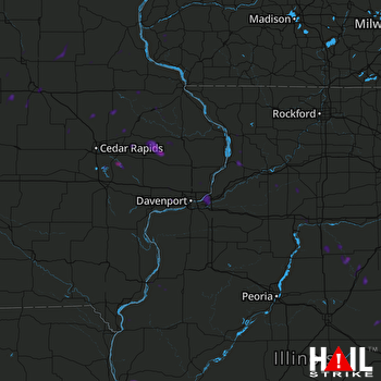 DAVENPORT (KDVN) RADAR

